Smygehamn geodata
Smygehamn (Skåne) is a populated place; located in Sweden in Europe/Stockholm (GMT+2) time zone. With population of 1,297 people, there are 713 cities with bigger population in this country. Compared to other cities in Sweden, 100% of cities are located further ↑North; 73.2% of cities are located further →East and 92.6% of cities have higher elevation than Smygehamn. Note1
Administrative division(s):
- Level 1: Skåne
- Level 2: Trelleborgs Kommun
- Level 3: Källstorp
- Level 4: Östra Torp socken


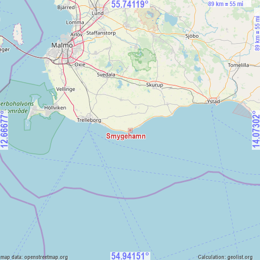
Smygehamn GPS coordinates[2]
55° 20' 36.132" North, 13° 22' 11.604" East
| Map corner | latitude | longitude |
|---|---|---|
| Upper-left | 55.74119°, | 12.66677° |
| Center: | 55.34337°, | 13.36989° |
| Lower-right: | 54.94151°, | 14.07302° |
| Map W x H: | 88.9×88.9 km | = 55.2×55.2mi |
| max Lat: | 67.85572° ⇑100% North |
| Smygehamn: | 55.34337° |
| min Lat: | ⇓0% South 55.34337° |
| min Long | Smygehamn | max Long |
| 11.1712° | 13.36989° | 24.13676° |
| W 26.8%⇐ | ⇒73.2% E |
Elevation
Elevation of Smygehamn is 7 m = 23 ft, and this is 75.6 m = 248 ft below average elevation for this country.
| Max E: |
663 m = 2175 ft | 92.6% |
| Avg. | 82.6 m = 271 ft | |
| Smygehamn | 7 m = 23 ft | |
Min E: |
-1 m = -3 ft | 7.4% |
See also: Sweden elevation on elevation.city.
Geographical zone
Smygehamn is located in North temperate zone (between Tropic of Cancer and the Arctic Circle). Distance of this North polar circle is 1247.6 km =775.2 mi to North.| Distance of | km | miles | from Smygehamn |
|---|---|---|---|
| North Pole | 3853.5 | 2394.5 | to North |
| Arctic Circle | 1247.6 | 775.2 | to North |
| Tropic Cancer | 3547.7 | 2204.4 | to South |
| Equator | 6153.6 | 3823.7 | to South |


Nearby cities:
15 places around Smygehamn: (largest is in red/bold)
• Abbekås
15.8 km =9.8 mi,  66°
66°
• Anderslöv
11 km =6.8 mi,  343°
343°
• Klagstorp
5.5 km =3.4 mi,  3°
3°
• Kurland
18.4 km =11.4 mi,  280°
280°
• Rydsgård
19.9 km =12.4 mi,  43°
43°
• Skegrie
19.8 km =12.3 mi,  290°
290°
• Skivarp
14.9 km =9.3 mi,  56°
56°
• Skurup
17.2 km =10.7 mi,  29°
29°
• Skåre
20.7 km =12.9 mi, 282°
• Svarte
23.9 km =14.9 mi, 65°
• Svedala
20.2 km =12.6 mi, 335°
• Trelleborg
13.9 km =8.6 mi, 284°
• Vellinge
26.3 km =16.3 mi,  302°
302°
• Västra Ingelstad
23.1 km =14.4 mi,  315°
315°
• Östra Grevie
20.3 km =12.6 mi,  312°
312°
Sources, notices
• [Note1] Compared only with cities in Sweden existing in our database
• [Src1] Map data: © OpenStreetMap contributors (CC-BY-SA)
• [Src2] Other city data from geonames.org with taken over terms of usage.
• [Src3] Geographical zone / Annual Mean Temperature by Robert A. Rohde @ Wikipedia
