Anderslöv geodata
Anderslöv (Skåne) is a populated place; located in Sweden in Europe/Stockholm (GMT+2) time zone. With population of 1,963 people, there are 529 cities with bigger population in this country. Compared to other cities in Sweden, 98.9% of cities are located further ↑North; 74% of cities are located further →East and 50.7% of cities have higher elevation than Anderslöv. Note1


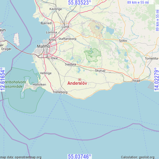
Anderslöv GPS coordinates[2]
55° 26' 18.096" North, 13° 19' 10.776" East
| Map corner | latitude | longitude |
|---|---|---|
| Upper-left | 55.83523°, | 12.61654° |
| Center: | 55.43836°, | 13.31966° |
| Lower-right: | 55.03746°, | 14.02279° |
| Map W x H: | 88.7×88.7 km | = 55.1×55.1mi |
| max Lat: | 67.85572° ⇑98.9% North |
| Anderslöv: | 55.43836° |
| min Lat: | ⇓1.1% South 55.34337° |
| min Long | Anderslöv | max Long |
| 11.1712° | 13.31966° | 24.13676° |
| W 26%⇐ | ⇒74% E |
Elevation
Elevation of Anderslöv is 49 m = 161 ft, and this is 33.6 m = 110 ft below average elevation for this country.
| Max E: |
663 m = 2175 ft | 50.7% |
| Avg. | 82.6 m = 271 ft | |
| Anderslöv | 49 m = 161 ft | |
Min E: |
-1 m = -3 ft | 49.3% |
See also: Sweden elevation on elevation.city.
Geographical zone
Anderslöv is located in North temperate zone (between Tropic of Cancer and the Arctic Circle). Distance of this North polar circle is 1237 km =768.6 mi to North.| Distance of | km | miles | from Anderslöv |
|---|---|---|---|
| North Pole | 3842.9 | 2387.9 | to North |
| Arctic Circle | 1237 | 768.6 | to North |
| Tropic Cancer | 3558.2 | 2211 | to South |
| Equator | 6164.2 | 3830.3 | to South |


Nearby cities:
15 places around Anderslöv: (largest is in red/bold)
• Abbekås
18.2 km =11.3 mi,  103°
103°
• Klagstorp
6.1 km =3.8 mi,  145°
145°
• Klågerup
17.9 km =11.1 mi,  344°
344°
• Kurland
16.5 km =10.3 mi,  244°
244°
• Oxie
18.1 km =11.2 mi,  308°
308°
• Rydsgård
17.4 km =10.8 mi,  77°
77°
• Skegrie
15.7 km =9.8 mi,  256°
256°
• Skivarp
15.8 km =9.8 mi, 98°
• Skurup
12.3 km =7.6 mi,  68°
68°
• Skåre
18.1 km =11.2 mi,  250°
250°
• Smygehamn
11 km =6.8 mi,  163°
163°
• Svedala
9.4 km =5.8 mi,  325°
325°
• Trelleborg
12.4 km =7.7 mi, 235°
• Västra Ingelstad
14.3 km =8.9 mi,  294°
294°
• Östra Grevie
12.2 km =7.6 mi,  284°
284°
Sources, notices
• [Note1] Compared only with cities in Sweden existing in our database
• [Src1] Map data: © OpenStreetMap contributors (CC-BY-SA)
• [Src2] Other city data from geonames.org with taken over terms of usage.
• [Src3] Geographical zone / Annual Mean Temperature by Robert A. Rohde @ Wikipedia
