Skurup geodata
Skurup (Skåne) is a seat of a second-order administrative division; located in Sweden in Europe/Stockholm (GMT+2) time zone. With population of 8,040 people, there are 181 cities with bigger population in this country. Compared to other cities in Sweden, 98.4% of cities are located further ↑North; 71.2% of cities are located further →East and 52.7% of cities have lower elevation than Skurup. Note1


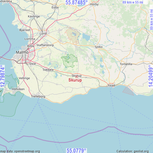
Skurup GPS coordinates[2]
55° 28' 42.204" North, 13° 30' 6.696" East
| Map corner | latitude | longitude |
|---|---|---|
| Upper-left | 55.87485°, | 12.79874° |
| Center: | 55.47839°, | 13.50186° |
| Lower-right: | 55.0779°, | 14.20499° |
| Map W x H: | 88.6×88.6 km | = 55.1×55.1mi |
| max Lat: | 67.85572° ⇑98.4% North |
| Skurup: | 55.47839° |
| min Lat: | ⇓1.6% South 55.34337° |
| min Long | Skurup | max Long |
| 11.1712° | 13.50186° | 24.13676° |
| W 28.8%⇐ | ⇒71.2% E |
Elevation
Elevation of Skurup is 55 m = 180 ft, and this is 27.6 m = 91 ft below average elevation for this country.
| Max E: |
663 m = 2175 ft | 47.3% |
| Avg. | 82.6 m = 271 ft | |
| Skurup | 55 m = 180 ft | |
Min E: |
-1 m = -3 ft | 52.7% |
See also: Sweden elevation on elevation.city.
Geographical zone
Skurup is located in North temperate zone (between Tropic of Cancer and the Arctic Circle). Distance of this North polar circle is 1232.6 km =765.9 mi to North.| Distance of | km | miles | from Skurup |
|---|---|---|---|
| North Pole | 3838.4 | 2385.1 | to North |
| Arctic Circle | 1232.6 | 765.9 | to North |
| Tropic Cancer | 3562.7 | 2213.8 | to South |
| Equator | 6168.6 | 3833 | to South |


Nearby cities:
15 places around Skurup: (largest is in red/bold)
• Abbekås
10.7 km =6.6 mi,  144°
144°
• Anderslöv
12.3 km =7.6 mi,  248°
248°
• Blentarp
13.2 km =8.2 mi,  27°
27°
• Genarp
14.9 km =9.3 mi,  334°
334°
• Idala
15.7 km =9.8 mi,  359°
359°
• Klagstorp
12.4 km =7.7 mi,  220°
220°
• Klågerup
20.6 km =12.8 mi,  308°
308°
• Rydsgård
5.5 km =3.4 mi,  96°
96°
• Sjöbo
21.3 km =13.2 mi,  37°
37°
• Skivarp
8 km =5 mi,  149°
149°
• Smygehamn
17.2 km =10.7 mi,  209°
209°
• Svarte
14.3 km =8.9 mi,  111°
111°
• Svedala
17.1 km =10.6 mi,  281°
281°
• Veberöd
17.3 km =10.7 mi, 356°
• Ystad
20.8 km =12.9 mi, 105°
Sources, notices
• [Note1] Compared only with cities in Sweden existing in our database
• [Src1] Map data: © OpenStreetMap contributors (CC-BY-SA)
• [Src2] Other city data from geonames.org with taken over terms of usage.
• [Src3] Geographical zone / Annual Mean Temperature by Robert A. Rohde @ Wikipedia
