Akalla geodata
Akalla (Stockholm) is a section of populated place; located in Sweden in Europe/Stockholm (GMT+2) time zone. With population of 8,153 people, there are 178 cities with bigger population in this country. Compared to other cities in Sweden, 64.4% of cities are located further ↓South; 84.9% of cities are located further ←West and 55.2% of cities have higher elevation than Akalla. Note1


Akalla GPS coordinates[2]
59° 24' 52.74" North, 17° 54' 50.328" East
| Map corner | latitude | longitude |
|---|---|---|
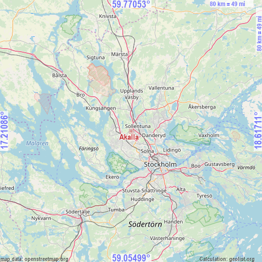
| Upper-left | 59.77053°, | 17.21086° |
| Center: | 59.41465°, | 17.91398° |
| Lower-right: | 59.05499°, | 18.61711° |
| Map W x H: | 79.6×79.6 km | = 49.5×49.5mi |
| max Lat: | 67.85572° ⇑35.6% North |
| Akalla: | 59.41465° |
| min Lat: | ⇓64.4% South 55.34337° |
| min Long | Akalla | max Long |
| 11.1712° | 17.91398° | 24.13676° |
| W 84.9%⇐ | ⇒15.1% E |
Elevation
Elevation of Akalla is 42 m = 138 ft, and this is 40.6 m = 133 ft below average elevation for this country.
| Max E: |
663 m = 2175 ft | 55.2% |
| Avg. | 82.6 m = 271 ft | |
| Akalla | 42 m = 138 ft | |
Min E: |
-1 m = -3 ft | 44.8% |
See also: Sweden elevation on elevation.city.
Geographical zone
Akalla is located in North temperate zone (between Tropic of Cancer and the Arctic Circle). Distance of this North polar circle is 794.9 km =493.9 mi to North.| Distance of | km | miles | from Akalla |
|---|---|---|---|
| North Pole | 3400.8 | 2113.2 | to North |
| Arctic Circle | 794.9 | 493.9 | to North |
| Tropic Cancer | 4000.4 | 2485.7 | to South |
| Equator | 6606.3 | 4105 | to South |


Nearby cities:
15 places around Akalla: (largest is in red/bold)
• Alvik
10 km =6.2 mi,  156°
156°
• Bergshamra
7.8 km =4.8 mi,  118°
118°
• Bromma
8.4 km =5.2 mi,  169°
169°
• Djursholm
8.2 km =5.1 mi,  102°
102°
• Enebyberg
8 km =5 mi,  74°
74°
• Jakobsberg
4.6 km =2.9 mi,  281°
281°
• Kista
2.2 km =1.4 mi,  126°
126°
• Råsunda
7.1 km =4.4 mi,  139°
139°
• Sollentuna
2.6 km =1.6 mi,  54°
54°
• Solna
7.8 km =4.8 mi, 140°
• Sundbyberg
6.8 km =4.2 mi,  151°
151°
• Tensta
2.4 km =1.5 mi,  197°
197°
• Täby
9.3 km =5.8 mi, 69°
• Upplands Väsby
11.5 km =7.1 mi,  359°
359°
• Vasastan
10.9 km =6.8 mi, 134°
Sources, notices
• [Note1] Compared only with cities in Sweden existing in our database
• [Src1] Map data: © OpenStreetMap contributors (CC-BY-SA)
• [Src2] Other city data from geonames.org with taken over terms of usage.
• [Src3] Geographical zone / Annual Mean Temperature by Robert A. Rohde @ Wikipedia
