Anneberg geodata
Anneberg (Jönköping) is a populated place; located in Sweden in Europe/Stockholm (GMT+2) time zone. With population of 834 people, there are 940 cities with bigger population in this country. Compared to other cities in Sweden, 66.4% of cities are located further ↑North; 53.3% of cities are located further →East and 92.6% of cities have lower elevation than Anneberg. Note1


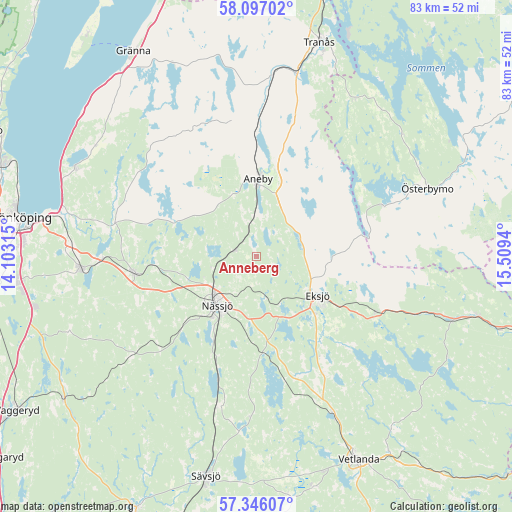
Anneberg GPS coordinates[2]
57° 43' 24.564" North, 14° 48' 22.572" East
| Map corner | latitude | longitude |
|---|---|---|
| Upper-left | 58.09702°, | 14.10315° |
| Center: | 57.72349°, | 14.80627° |
| Lower-right: | 57.34607°, | 15.5094° |
| Map W x H: | 83.5×83.5 km | = 51.9×51.9mi |
| max Lat: | 67.85572° ⇑66.4% North |
| Anneberg: | 57.72349° |
| min Lat: | ⇓33.6% South 55.34337° |
| min Long | Anneberg | max Long |
| 11.1712° | 14.80627° | 24.13676° |
| W 46.7%⇐ | ⇒53.3% E |
Elevation
Elevation of Anneberg is 226 m = 741 ft, and this is 143.4 m = 470 ft above average elevation for this country.
| Max E: |
663 m = 2175 ft | 7.4% |
| Anneberg | 226 m 741 ft | |
| Avg. | 82.6 m = 271 ft | |
Min E: |
-1 m = -3 ft | 92.6% |
See also: Sweden elevation on elevation.city.
Geographical zone
Anneberg is located in North temperate zone (between Tropic of Cancer and the Arctic Circle). Distance of this North polar circle is 982.9 km =610.7 mi to North.| Distance of | km | miles | from Anneberg |
|---|---|---|---|
| North Pole | 3588.8 | 2230 | to North |
| Arctic Circle | 982.9 | 610.7 | to North |
| Tropic Cancer | 3812.3 | 2368.9 | to South |
| Equator | 6418.3 | 3988.1 | to South |


Nearby cities:
15 places around Anneberg: (largest is in red/bold)
• Aneby
12.8 km =8 mi,  1°
1°
• Bodafors
25.6 km =15.9 mi,  194°
194°
• Ekenässjön
28.8 km =17.9 mi,  153°
153°
• Eksjö
11.7 km =7.3 mi,  122°
122°
• Forserum
20.3 km =12.6 mi,  262°
262°
• Hestra
25.2 km =15.7 mi,  328°
328°
• Huskvarna
30.7 km =19.1 mi,  283°
283°
• Hällaryd
35.7 km =22.2 mi,  143°
143°
• Kaxholmen
33.1 km =20.6 mi,  295°
295°
• Lekeryd
24.6 km =15.3 mi, 281°
• Malmbäck
26.2 km =16.3 mi,  231°
231°
• Nässjö
10.2 km =6.3 mi,  219°
219°
• Ryssby
9.3 km =5.8 mi,  265°
265°
• Tenhult
28.8 km =17.9 mi, 266°
• Österbymo
29.9 km =18.6 mi,  67°
67°
Sources, notices
• [Note1] Compared only with cities in Sweden existing in our database
• [Src1] Map data: © OpenStreetMap contributors (CC-BY-SA)
• [Src2] Other city data from geonames.org with taken over terms of usage.
• [Src3] Geographical zone / Annual Mean Temperature by Robert A. Rohde @ Wikipedia
