Bodafors geodata
Bodafors (Jönköping) is a populated place; located in Sweden in Europe/Stockholm (GMT+2) time zone. With population of 1,957 people, there are 532 cities with bigger population in this country. Compared to other cities in Sweden, 71.5% of cities are located further ↑North; 54.2% of cities are located further →East and 95.5% of cities have lower elevation than Bodafors. Note1


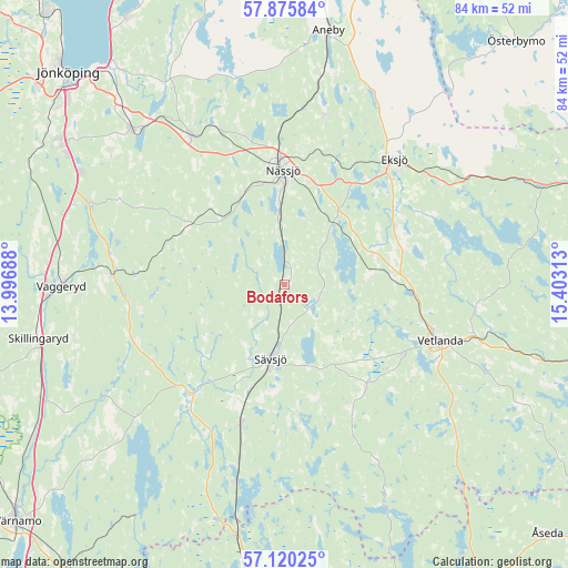
Bodafors GPS coordinates[2]
57° 30' 0" North, 14° 42' 0" East
| Map corner | latitude | longitude |
|---|---|---|
| Upper-left | 57.87584°, | 13.99688° |
| Center: | 57.5°, | 14.7° |
| Lower-right: | 57.12025°, | 15.40313° |
| Map W x H: | 84×84 km | = 52.2×52.2mi |
| max Lat: | 67.85572° ⇑71.5% North |
| Bodafors: | 57.5° |
| min Lat: | ⇓28.5% South 55.34337° |
| min Long | Bodafors | max Long |
| 11.1712° | 14.7° | 24.13676° |
| W 45.8%⇐ | ⇒54.2% E |
Elevation
Elevation of Bodafors is 276 m = 906 ft, and this is 193.4 m = 635 ft above average elevation for this country.
| Max E: |
663 m = 2175 ft | 4.5% |
| Bodafors | 276 m 906 ft | |
| Avg. | 82.6 m = 271 ft | |
Min E: |
-1 m = -3 ft | 95.5% |
See also: Sweden elevation on elevation.city.
Geographical zone
Bodafors is located in North temperate zone (between Tropic of Cancer and the Arctic Circle). Distance of this North polar circle is 1007.8 km =626.2 mi to North.| Distance of | km | miles | from Bodafors |
|---|---|---|---|
| North Pole | 3613.7 | 2245.4 | to North |
| Arctic Circle | 1007.8 | 626.2 | to North |
| Tropic Cancer | 3787.5 | 2353.4 | to South |
| Equator | 6393.4 | 3972.7 | to South |


Nearby cities:
15 places around Bodafors: (largest is in red/bold)
• Anneberg
25.6 km =15.9 mi,  14°
14°
• Burseryd
15.6 km =9.7 mi,  161°
161°
• Ekenässjön
19.3 km =12 mi,  92°
92°
• Eksjö
24.6 km =15.3 mi,  41°
41°
• Forserum
26.2 km =16.3 mi,  327°
327°
• Hok
25.3 km =15.7 mi,  273°
273°
• Landsbro
19.1 km =11.9 mi,  141°
141°
• Malmbäck
16.6 km =10.3 mi,  300°
300°
• Myresjö
20.3 km =12.6 mi,  129°
129°
• Nässjö
17 km =10.6 mi,  359°
359°
• Ryssby
24.3 km =15.1 mi,  352°
352°
• Stockaryd
21.3 km =13.2 mi,  197°
197°
• Sävsjö
11 km =6.8 mi,  191°
191°
• Vetlanda
23.9 km =14.9 mi,  109°
109°
• Vrigstad
21.8 km =13.5 mi,  219°
219°
Sources, notices
• [Note1] Compared only with cities in Sweden existing in our database
• [Src1] Map data: © OpenStreetMap contributors (CC-BY-SA)
• [Src2] Other city data from geonames.org with taken over terms of usage.
• [Src3] Geographical zone / Annual Mean Temperature by Robert A. Rohde @ Wikipedia
