Simrishamn geodata
Simrishamn (Skåne) is a seat of a second-order administrative division; located in Sweden in Europe/Stockholm (GMT+2) time zone. With population of 6,779 people, there are 212 cities with bigger population in this country. Compared to other cities in Sweden, 97.5% of cities are located further ↑North; 58.7% of cities are located further →East and 85.7% of cities have higher elevation than Simrishamn. Note1


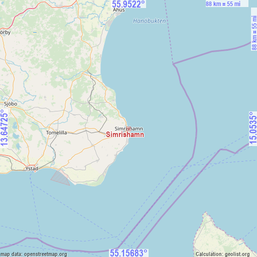
Simrishamn GPS coordinates[2]
55° 33' 23.508" North, 14° 21' 1.332" East
| Map corner | latitude | longitude |
|---|---|---|
| Upper-left | 55.9522°, | 13.64725° |
| Center: | 55.55653°, | 14.35037° |
| Lower-right: | 55.15683°, | 15.0535° |
| Map W x H: | 88.4×88.4 km | = 54.9×54.9mi |
| max Lat: | 67.85572° ⇑97.5% North |
| Simrishamn: | 55.55653° |
| min Lat: | ⇓2.5% South 55.34337° |
| min Long | Simrishamn | max Long |
| 11.1712° | 14.35037° | 24.13676° |
| W 41.3%⇐ | ⇒58.7% E |
Elevation
Elevation of Simrishamn is 12 m = 39 ft, and this is 70.6 m = 232 ft below average elevation for this country.
| Max E: |
663 m = 2175 ft | 85.7% |
| Avg. | 82.6 m = 271 ft | |
| Simrishamn | 12 m = 39 ft | |
Min E: |
-1 m = -3 ft | 14.3% |
See also: Sweden elevation on elevation.city.
Geographical zone
Simrishamn is located in North temperate zone (between Tropic of Cancer and the Arctic Circle). Distance of this North polar circle is 1223.9 km =760.5 mi to North.| Distance of | km | miles | from Simrishamn |
|---|---|---|---|
| North Pole | 3829.8 | 2379.7 | to North |
| Arctic Circle | 1223.9 | 760.5 | to North |
| Tropic Cancer | 3571.4 | 2219.2 | to South |
| Equator | 6177.3 | 3838.4 | to South |


Nearby cities:
15 places around Simrishamn: (largest is in red/bold)
• Borrby
15.4 km =9.6 mi,  224°
224°
• Brösarp
24.3 km =15.1 mi,  320°
320°
• Degeberga
35 km =21.7 mi,  331°
331°
• Gärsnäs
10.8 km =6.7 mi,  265°
265°
• Hammenhög
14.1 km =8.8 mi,  243°
243°
• Kivik
16.5 km =10.3 mi, 330°
• Köpingebro
28.5 km =17.7 mi,  246°
246°
• Löderup
20.1 km =12.5 mi,  227°
227°
• Lövestad
30.7 km =19.1 mi,  290°
290°
• Onslunda
19.4 km =12.1 mi,  283°
283°
• Sankt Olof
16.1 km =10 mi,  302°
302°
• Skillinge
11.3 km =7 mi,  206°
206°
• Tomelilla
24.9 km =15.5 mi, 266°
• Yngsjö
36.7 km =22.8 mi,  349°
349°
• Ystad
36.2 km =22.5 mi, 247°
Sources, notices
• [Note1] Compared only with cities in Sweden existing in our database
• [Src1] Map data: © OpenStreetMap contributors (CC-BY-SA)
• [Src2] Other city data from geonames.org with taken over terms of usage.
• [Src3] Geographical zone / Annual Mean Temperature by Robert A. Rohde @ Wikipedia
