Gärsnäs geodata
Gärsnäs (Skåne) is a populated place; located in Sweden in Europe/Stockholm (GMT+2) time zone. With population of 1,094 people, there are 774 cities with bigger population in this country. Compared to other cities in Sweden, 97.6% of cities are located further ↑North; 61.1% of cities are located further →East and 56.2% of cities have lower elevation than Gärsnäs. Note1
Administrative division(s):
- Level 1: Skåne
- Level 2: Simrishamns kommun
- Level 3: Stiby
- Level 4: Stiby socken


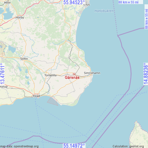
Gärsnäs GPS coordinates[2]
55° 32' 58.164" North, 14° 10' 45.228" East
| Map corner | latitude | longitude |
|---|---|---|
| Upper-left | 55.94523°, | 13.47611° |
| Center: | 55.54949°, | 14.17923° |
| Lower-right: | 55.14972°, | 14.88236° |
| Map W x H: | 88.5×88.5 km | = 55×55mi |
| max Lat: | 67.85572° ⇑97.6% North |
| Gärsnäs: | 55.54949° |
| min Lat: | ⇓2.4% South 55.34337° |
| min Long | Gärsnäs | max Long |
| 11.1712° | 14.17923° | 24.13676° |
| W 38.9%⇐ | ⇒61.1% E |
Elevation
Elevation of Gärsnäs is 62 m = 203 ft, and this is 20.6 m = 68 ft below average elevation for this country.
| Max E: |
663 m = 2175 ft | 43.8% |
| Avg. | 82.6 m = 271 ft | |
| Gärsnäs | 62 m = 203 ft | |
Min E: |
-1 m = -3 ft | 56.2% |
See also: Sweden elevation on elevation.city.
Geographical zone
Gärsnäs is located in North temperate zone (between Tropic of Cancer and the Arctic Circle). Distance of this North polar circle is 1224.6 km =760.9 mi to North.| Distance of | km | miles | from Gärsnäs |
|---|---|---|---|
| North Pole | 3830.5 | 2380.2 | to North |
| Arctic Circle | 1224.6 | 760.9 | to North |
| Tropic Cancer | 3570.6 | 2218.7 | to South |
| Equator | 6176.5 | 3837.9 | to South |


Nearby cities:
15 places around Gärsnäs: (largest is in red/bold)
• Borrby
10.3 km =6.4 mi,  179°
179°
• Brösarp
20 km =12.4 mi,  346°
346°
• Hammenhög
5.8 km =3.6 mi,  198°
198°
• Kivik
15.3 km =9.5 mi,  9°
9°
• Köpingebro
18.6 km =11.6 mi,  235°
235°
• Löderup
13.5 km =8.4 mi, 196°
• Lövestad
21.4 km =13.3 mi,  302°
302°
• Onslunda
9.7 km =6 mi, 303°
• Sankt Olof
9.8 km =6.1 mi,  342°
342°
• Simrishamn
10.8 km =6.7 mi,  85°
85°
• Sjöbo
31.1 km =19.3 mi,  287°
287°
• Skillinge
11 km =6.8 mi,  148°
148°
• Tomelilla
14.1 km =8.8 mi,  267°
267°
• Vollsjö
29.6 km =18.4 mi, 304°
• Ystad
26.2 km =16.3 mi, 239°
Sources, notices
• [Note1] Compared only with cities in Sweden existing in our database
• [Src1] Map data: © OpenStreetMap contributors (CC-BY-SA)
• [Src2] Other city data from geonames.org with taken over terms of usage.
• [Src3] Geographical zone / Annual Mean Temperature by Robert A. Rohde @ Wikipedia
