Brösarp geodata
Brösarp (Skåne) is a populated place; located in Sweden in Europe/Stockholm (GMT+2) time zone. With population of 719 people, there are 1043 cities with bigger population in this country. Compared to other cities in Sweden, 95.7% of cities are located further ↑North; 62.9% of cities are located further →East and 54.7% of cities have higher elevation than Brösarp. Note1


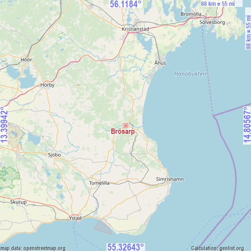
Brösarp GPS coordinates[2]
55° 43' 27.912" North, 14° 6' 9.144" East
| Map corner | latitude | longitude |
|---|---|---|
| Upper-left | 56.1184°, | 13.39942° |
| Center: | 55.72442°, | 14.10254° |
| Lower-right: | 55.32643°, | 14.80567° |
| Map W x H: | 88.1×88.1 km | = 54.7×54.7mi |
| max Lat: | 67.85572° ⇑95.7% North |
| Brösarp: | 55.72442° |
| min Lat: | ⇓4.3% South 55.34337° |
| min Long | Brösarp | max Long |
| 11.1712° | 14.10254° | 24.13676° |
| W 37.1%⇐ | ⇒62.9% E |
Elevation
Elevation of Brösarp is 43 m = 141 ft, and this is 39.6 m = 130 ft below average elevation for this country.
| Max E: |
663 m = 2175 ft | 54.7% |
| Avg. | 82.6 m = 271 ft | |
| Brösarp | 43 m = 141 ft | |
Min E: |
-1 m = -3 ft | 45.3% |
See also: Sweden elevation on elevation.city.
Geographical zone
Brösarp is located in North temperate zone (between Tropic of Cancer and the Arctic Circle). Distance of this North polar circle is 1205.2 km =748.9 mi to North.| Distance of | km | miles | from Brösarp |
|---|---|---|---|
| North Pole | 3811.1 | 2368.1 | to North |
| Arctic Circle | 1205.2 | 748.9 | to North |
| Tropic Cancer | 3590.1 | 2230.8 | to South |
| Equator | 6196 | 3850 | to South |


Nearby cities:
15 places around Brösarp: (largest is in red/bold)
• Degeberga
12.2 km =7.6 mi,  354°
354°
• Everöd
19.5 km =12.1 mi,  359°
359°
• Gärds Köpinge
23.4 km =14.5 mi,  7°
7°
• Gärsnäs
20 km =12.4 mi,  166°
166°
• Hammenhög
25.1 km =15.6 mi, 173°
• Kivik
8.6 km =5.3 mi,  120°
120°
• Lövestad
15.4 km =9.6 mi,  238°
238°
• Onslunda
14.4 km =8.9 mi,  192°
192°
• Sankt Olof
10.3 km =6.4 mi, 169°
• Simrishamn
24.3 km =15.1 mi,  140°
140°
• Tollarp
24.4 km =15.2 mi,  342°
342°
• Tomelilla
22.2 km =13.8 mi,  204°
204°
• Vollsjö
19.7 km =12.2 mi,  262°
262°
• Yngsjö
19.5 km =12.1 mi,  26°
26°
• Åhus
24.2 km =15 mi, 27°
Sources, notices
• [Note1] Compared only with cities in Sweden existing in our database
• [Src1] Map data: © OpenStreetMap contributors (CC-BY-SA)
• [Src2] Other city data from geonames.org with taken over terms of usage.
• [Src3] Geographical zone / Annual Mean Temperature by Robert A. Rohde @ Wikipedia
