Sankt Olof geodata
Sankt Olof (Skåne) is a populated place; located in Sweden in Europe/Stockholm (GMT+2) time zone. With population of 666 people, there are 1101 cities with bigger population in this country. Compared to other cities in Sweden, 96.7% of cities are located further ↑North; 62.4% of cities are located further →East and 76.9% of cities have lower elevation than Sankt Olof. Note1


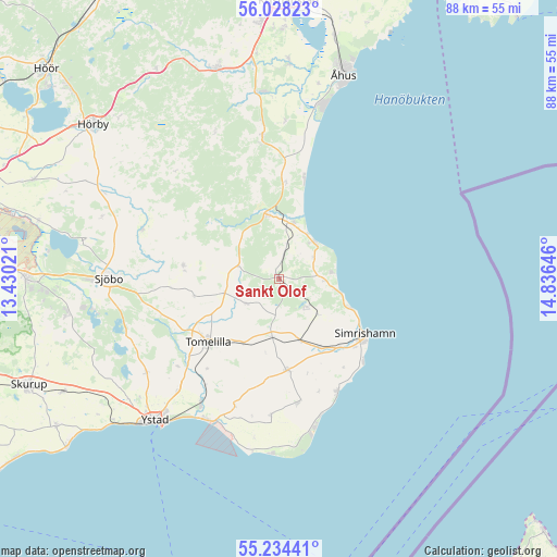
Sankt Olof GPS coordinates[2]
55° 37' 59.988" North, 14° 7' 59.988" East
| Map corner | latitude | longitude |
|---|---|---|
| Upper-left | 56.02823°, | 13.43021° |
| Center: | 55.63333°, | 14.13333° |
| Lower-right: | 55.23441°, | 14.83646° |
| Map W x H: | 88.3×88.3 km | = 54.9×54.9mi |
| max Lat: | 67.85572° ⇑96.7% North |
| Sankt Olof: | 55.63333° |
| min Lat: | ⇓3.3% South 55.34337° |
| min Long | Sankt Olof | max Long |
| 11.1712° | 14.13333° | 24.13676° |
| W 37.6%⇐ | ⇒62.4% E |
Elevation
Elevation of Sankt Olof is 127 m = 417 ft, and this is 44.4 m = 146 ft above average elevation for this country.
| Max E: |
663 m = 2175 ft | 23.1% |
| Sankt Olof | 127 m 417 ft | |
| Avg. | 82.6 m = 271 ft | |
Min E: |
-1 m = -3 ft | 76.9% |
See also: Sweden elevation on elevation.city.
Geographical zone
Sankt Olof is located in North temperate zone (between Tropic of Cancer and the Arctic Circle). Distance of this North polar circle is 1215.3 km =755.2 mi to North.| Distance of | km | miles | from Sankt Olof |
|---|---|---|---|
| North Pole | 3821.2 | 2374.4 | to North |
| Arctic Circle | 1215.3 | 755.2 | to North |
| Tropic Cancer | 3579.9 | 2224.4 | to South |
| Equator | 6185.8 | 3843.7 | to South |


Nearby cities:
15 places around Sankt Olof: (largest is in red/bold)
• Borrby
19.8 km =12.3 mi,  171°
171°
• Brösarp
10.3 km =6.4 mi,  349°
349°
• Degeberga
22.5 km =14 mi, 351°
• Gärsnäs
9.8 km =6.1 mi,  162°
162°
• Hammenhög
14.9 km =9.3 mi,  175°
175°
• Kivik
7.9 km =4.9 mi,  43°
43°
• Köpingebro
23.4 km =14.5 mi,  212°
212°
• Löderup
22.3 km =13.9 mi, 182°
• Lövestad
15.3 km =9.5 mi,  278°
278°
• Onslunda
6.5 km =4 mi,  232°
232°
• Simrishamn
16.1 km =10 mi,  122°
122°
• Sjöbo
26.8 km =16.7 mi,  269°
269°
• Skillinge
20.6 km =12.8 mi, 155°
• Tomelilla
15.1 km =9.4 mi, 228°
• Vollsjö
22.7 km =14.1 mi,  289°
289°
Sources, notices
• [Note1] Compared only with cities in Sweden existing in our database
• [Src1] Map data: © OpenStreetMap contributors (CC-BY-SA)
• [Src2] Other city data from geonames.org with taken over terms of usage.
• [Src3] Geographical zone / Annual Mean Temperature by Robert A. Rohde @ Wikipedia
