Selja geodata
Selja (Dalarna) is a populated place; located in Sweden in Europe/Stockholm (GMT+2) time zone. With population of 547 people, there are 1239 cities with bigger population in this country. Compared to other cities in Sweden, 82.8% of cities are located further ↓South; 57.6% of cities are located further →East and 85.8% of cities have lower elevation than Selja. Note1


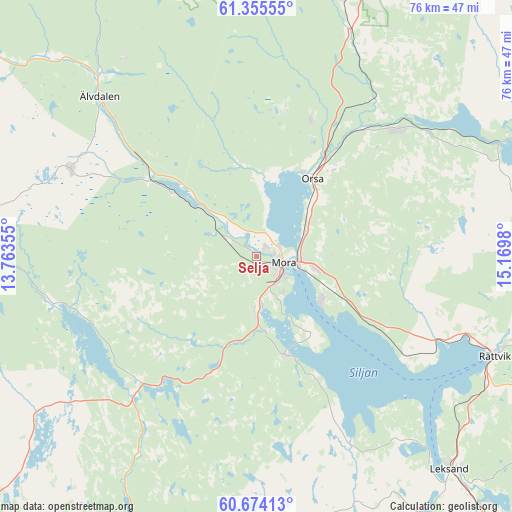
Selja GPS coordinates[2]
61° 1' 0.012" North, 14° 28' 0.012" East
| Map corner | latitude | longitude |
|---|---|---|
| Upper-left | 61.35555°, | 13.76355° |
| Center: | 61.01667°, | 14.46667° |
| Lower-right: | 60.67413°, | 15.1698° |
| Map W x H: | 75.8×75.8 km | = 47.1×47.1mi |
| max Lat: | 67.85572° ⇑17.2% North |
| Selja: | 61.01667° |
| min Lat: | ⇓82.8% South 55.34337° |
| min Long | Selja | max Long |
| 11.1712° | 14.46667° | 24.13676° |
| W 42.4%⇐ | ⇒57.6% E |
Elevation
Elevation of Selja is 172 m = 564 ft, and this is 89.4 m = 293 ft above average elevation for this country.
| Max E: |
663 m = 2175 ft | 14.2% |
| Selja | 172 m 564 ft | |
| Avg. | 82.6 m = 271 ft | |
Min E: |
-1 m = -3 ft | 85.8% |
See also: Sweden elevation on elevation.city.
Geographical zone
Selja is located in North temperate zone (between Tropic of Cancer and the Arctic Circle). Distance of this North polar circle is 616.8 km =383.3 mi to North.| Distance of | km | miles | from Selja |
|---|---|---|---|
| North Pole | 3222.6 | 2002.4 | to North |
| Arctic Circle | 616.8 | 383.3 | to North |
| Tropic Cancer | 4178.5 | 2596.4 | to South |
| Equator | 6784.4 | 4215.6 | to South |


Nearby cities:
15 places around Selja: (largest is in red/bold)
• Backa
35.7 km =22.2 mi,  106°
106°
• Boda
40.4 km =25.1 mi,  90°
90°
• Färnäs
9.2 km =5.7 mi,  101°
101°
• Mora
4.3 km =2.7 mi, 104°
• Nusnäs
10.6 km =6.6 mi,  121°
121°
• Orsa
14 km =8.7 mi,  34°
34°
• Rot
34.8 km =21.6 mi,  318°
318°
• Rättvik
38 km =23.6 mi, 112°
• Siljansnäs
33.2 km =20.6 mi,  141°
141°
• Sollerön
13.8 km =8.6 mi, 143°
• Tällberg
36.4 km =22.6 mi,  127°
127°
• Vikarbyn
31.7 km =19.7 mi, 110°
• Våmhus
10.9 km =6.8 mi,  1°
1°
• Älvdalen
32.8 km =20.4 mi, 315°
• Östnor
2.1 km =1.3 mi, 25°
Sources, notices
• [Note1] Compared only with cities in Sweden existing in our database
• [Src1] Map data: © OpenStreetMap contributors (CC-BY-SA)
• [Src2] Other city data from geonames.org with taken over terms of usage.
• [Src3] Geographical zone / Annual Mean Temperature by Robert A. Rohde @ Wikipedia
