Mora geodata
Mora (Dalarna) is a seat of a second-order administrative division; located in Sweden in Europe/Stockholm (GMT+2) time zone. With population of 12,602 people, there are 125 cities with bigger population in this country. Compared to other cities in Sweden, 82.7% of cities are located further ↓South; 56.3% of cities are located further →East and 83.6% of cities have lower elevation than Mora. Note1


Mora GPS coordinates[2]
61° 0' 25.344" North, 14° 32' 35.376" East
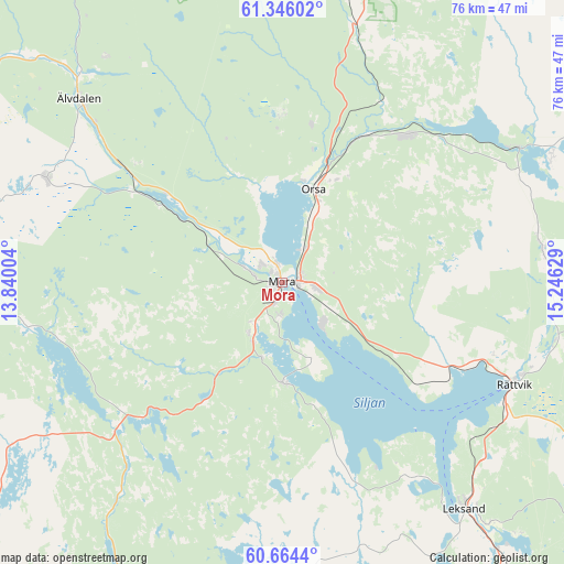
| Map corner | latitude | longitude |
|---|---|---|
| Upper-left | 61.34602°, | 13.84004° |
| Center: | 61.00704°, | 14.54316° |
| Lower-right: | 60.6644°, | 15.24629° |
| Map W x H: | 75.8×75.8 km | = 47.1×47.1mi |
| max Lat: | 67.85572° ⇑17.3% North |
| Mora: | 61.00704° |
| min Lat: | ⇓82.7% South 55.34337° |
| min Long | Mora | max Long |
| 11.1712° | 14.54316° | 24.13676° |
| W 43.7%⇐ | ⇒56.3% E |
Elevation
Elevation of Mora is 162 m = 531 ft, and this is 79.4 m = 260 ft above average elevation for this country.
| Max E: |
663 m = 2175 ft | 16.4% |
| Mora | 162 m 531 ft | |
| Avg. | 82.6 m = 271 ft | |
Min E: |
-1 m = -3 ft | 83.6% |
See also: Sweden elevation on elevation.city.
Geographical zone
Mora is located in North temperate zone (between Tropic of Cancer and the Arctic Circle). Distance of this North polar circle is 617.8 km =383.9 mi to North.| Distance of | km | miles | from Mora |
|---|---|---|---|
| North Pole | 3223.7 | 2003.1 | to North |
| Arctic Circle | 617.8 | 383.9 | to North |
| Tropic Cancer | 4177.4 | 2595.7 | to South |
| Equator | 6783.3 | 4214.9 | to South |


Nearby cities:
15 places around Mora: (largest is in red/bold)
• Backa
31.5 km =19.6 mi,  107°
107°
• Boda
36.3 km =22.6 mi,  88°
88°
• Färnäs
4.9 km =3 mi,  99°
99°
• Nusnäs
6.6 km =4.1 mi,  132°
132°
• Orsa
13.2 km =8.2 mi,  17°
17°
• Rot
38.5 km =23.9 mi,  314°
314°
• Rättvik
33.8 km =21 mi, 113°
• Selja
4.3 km =2.7 mi,  284°
284°
• Siljansnäs
29.9 km =18.6 mi,  146°
146°
• Sollerön
10.8 km =6.7 mi,  158°
158°
• Tällberg
32.5 km =20.2 mi, 130°
• Vikarbyn
27.5 km =17.1 mi, 111°
• Våmhus
12.6 km =7.8 mi,  342°
342°
• Älvdalen
36.5 km =22.7 mi, 312°
• Östnor
4.4 km =2.7 mi, 312°
Sources, notices
• [Note1] Compared only with cities in Sweden existing in our database
• [Src1] Map data: © OpenStreetMap contributors (CC-BY-SA)
• [Src2] Other city data from geonames.org with taken over terms of usage.
• [Src3] Geographical zone / Annual Mean Temperature by Robert A. Rohde @ Wikipedia
