Östersund geodata
Östersund (Jämtland) is a seat of a first-order administrative division; located in Sweden in Europe/Stockholm (GMT+2) time zone. With population of 49,806 people, there are 30 cities with bigger population in this country. Compared to other cities in Sweden, 89.6% of cities are located further ↓South; 54.9% of cities are located further →East and 97.4% of cities have lower elevation than Östersund. Note1


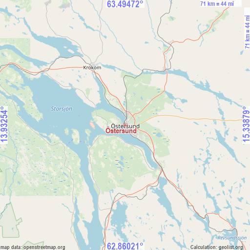
Östersund GPS coordinates[2]
63° 10' 45.12" North, 14° 38' 8.376" East
| Map corner | latitude | longitude |
|---|---|---|
| Upper-left | 63.49472°, | 13.93254° |
| Center: | 63.1792°, | 14.63566° |
| Lower-right: | 62.86021°, | 15.33879° |
| Map W x H: | 70.6×70.5 km | = 43.9×43.8mi |
| max Lat: | 67.85572° ⇑10.4% North |
| Östersund: | 63.1792° |
| min Lat: | ⇓89.6% South 55.34337° |
| min Long | Östersund | max Long |
| 11.1712° | 14.63566° | 24.13676° |
| W 45.1%⇐ | ⇒54.9% E |
Elevation
Elevation of Östersund is 328 m = 1076 ft, and this is 245.4 m = 805 ft above average elevation for this country.
| Max E: |
663 m = 2175 ft | 2.6% |
| Östersund | 328 m 1076 ft | |
| Avg. | 82.6 m = 271 ft | |
Min E: |
-1 m = -3 ft | 97.4% |
See also: Östersund elevation on elevation.city.
Geographical zone
Östersund is located in North temperate zone (between Tropic of Cancer and the Arctic Circle). Distance of this North polar circle is 376.3 km =233.8 mi to North.| Distance of | km | miles | from Östersund |
|---|---|---|---|
| North Pole | 2982.2 | 1853.1 | to North |
| Arctic Circle | 376.3 | 233.8 | to North |
| Tropic Cancer | 4418.9 | 2745.8 | to South |
| Equator | 7024.9 | 4365.1 | to South |


Nearby cities:
15 places around Östersund: (largest is in red/bold)
• Brunflo
15.1 km =9.4 mi,  139°
139°
• Dvärsätt
17.5 km =10.9 mi,  331°
331°
• Föllinge
54.2 km =33.7 mi,  359°
359°
• Gällö
42.2 km =26.2 mi,  134°
134°
• Hackås
29.8 km =18.5 mi,  191°
191°
• Hammerdal
57.2 km =35.5 mi,  39°
39°
• Hoverberg
41.7 km =25.9 mi, 193°
• Hållsta
26 km =16.2 mi, 140°
• Krokom
18.8 km =11.7 mi, 330°
• Lit
18.9 km =11.7 mi,  33°
33°
• Mörsil
50.8 km =31.6 mi,  286°
286°
• Nälden
27.1 km =16.8 mi,  314°
314°
• Stugun
48.4 km =30.1 mi,  91°
91°
• Svenstavik
47 km =29.2 mi, 192°
• Ås
8.6 km =5.3 mi,  336°
336°
Sources, notices
• [Note1] Compared only with cities in Sweden existing in our database
• [Src1] Map data: © OpenStreetMap contributors (CC-BY-SA)
• [Src2] Other city data from geonames.org with taken over terms of usage.
• [Src3] Geographical zone / Annual Mean Temperature by Robert A. Rohde @ Wikipedia
