Nälden geodata
Nälden (Jämtland) is a populated place; located in Sweden in Europe/Stockholm (GMT+2) time zone. With population of 986 people, there are 828 cities with bigger population in this country. Compared to other cities in Sweden, 90.6% of cities are located further ↓South; 60.2% of cities are located further →East and 97% of cities have lower elevation than Nälden. Note1


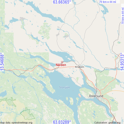
Nälden GPS coordinates[2]
63° 21' 0" North, 14° 15' 0" East
| Map corner | latitude | longitude |
|---|---|---|
| Upper-left | 63.66365°, | 13.54688° |
| Center: | 63.35°, | 14.25° |
| Lower-right: | 63.03289°, | 14.95313° |
| Map W x H: | 70.1×70.1 km | = 43.6×43.6mi |
| max Lat: | 67.85572° ⇑9.4% North |
| Nälden: | 63.35° |
| min Lat: | ⇓90.6% South 55.34337° |
| min Long | Nälden | max Long |
| 11.1712° | 14.25° | 24.13676° |
| W 39.8%⇐ | ⇒60.2% E |
Elevation
Elevation of Nälden is 321 m = 1053 ft, and this is 238.4 m = 782 ft above average elevation for this country.
| Max E: |
663 m = 2175 ft | 3% |
| Nälden | 321 m 1053 ft | |
| Avg. | 82.6 m = 271 ft | |
Min E: |
-1 m = -3 ft | 97% |
See also: Sweden elevation on elevation.city.
Geographical zone
Nälden is located in North temperate zone (between Tropic of Cancer and the Arctic Circle). Distance of this North polar circle is 357.3 km =222 mi to North.| Distance of | km | miles | from Nälden |
|---|---|---|---|
| North Pole | 2963.2 | 1841.2 | to North |
| Arctic Circle | 357.3 | 222 | to North |
| Tropic Cancer | 4437.9 | 2757.6 | to South |
| Equator | 7043.9 | 4376.9 | to South |


Nearby cities:
15 places around Nälden: (largest is in red/bold)
• Björnänge
55.8 km =34.7 mi,  273°
273°
• Brunflo
42.2 km =26.2 mi,  136°
136°
• Dvärsätt
11.4 km =7.1 mi,  108°
108°
• Föllinge
39.6 km =24.6 mi,  27°
27°
• Hackås
50 km =31.1 mi,  164°
164°
• Hållsta
53 km =32.9 mi, 137°
• Järpen
39.1 km =24.3 mi, 269°
• Krokom
10.3 km =6.4 mi, 105°
• Lit
29.9 km =18.6 mi,  96°
96°
• Mörsil
29.6 km =18.4 mi,  261°
261°
• Undersåker
50.1 km =31.1 mi, 265°
• Valla
31.5 km =19.6 mi,  314°
314°
• Åre
58.6 km =36.4 mi,  275°
275°
• Ås
19.3 km =12 mi,  125°
125°
• Östersund
27.1 km =16.8 mi, 134°
Sources, notices
• [Note1] Compared only with cities in Sweden existing in our database
• [Src1] Map data: © OpenStreetMap contributors (CC-BY-SA)
• [Src2] Other city data from geonames.org with taken over terms of usage.
• [Src3] Geographical zone / Annual Mean Temperature by Robert A. Rohde @ Wikipedia
