Hackås geodata
Hackås (Jämtland) is a populated place; located in Sweden in Europe/Stockholm (GMT+2) time zone. With population of 531 people, there are 1270 cities with bigger population in this country. Compared to other cities in Sweden, 88.7% of cities are located further ↓South; 56.8% of cities are located further →East and 97.3% of cities have lower elevation than Hackås. Note1


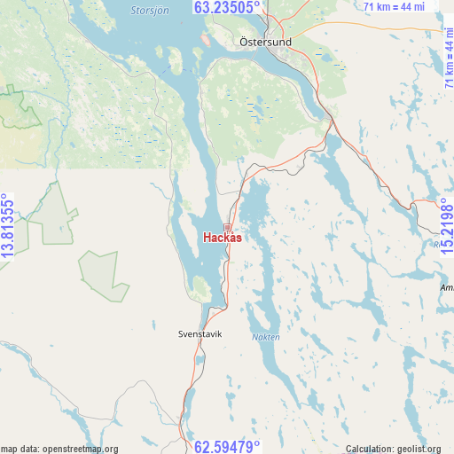
Hackås GPS coordinates[2]
62° 55' 0.012" North, 14° 31' 0.012" East
| Map corner | latitude | longitude |
|---|---|---|
| Upper-left | 63.23505°, | 13.81355° |
| Center: | 62.91667°, | 14.51667° |
| Lower-right: | 62.59479°, | 15.2198° |
| Map W x H: | 71.2×71.2 km | = 44.2×44.2mi |
| max Lat: | 67.85572° ⇑11.3% North |
| Hackås: | 62.91667° |
| min Lat: | ⇓88.7% South 55.34337° |
| min Long | Hackås | max Long |
| 11.1712° | 14.51667° | 24.13676° |
| W 43.2%⇐ | ⇒56.8% E |
Elevation
Elevation of Hackås is 326 m = 1070 ft, and this is 243.4 m = 799 ft above average elevation for this country.
| Max E: |
663 m = 2175 ft | 2.7% |
| Hackås | 326 m 1070 ft | |
| Avg. | 82.6 m = 271 ft | |
Min E: |
-1 m = -3 ft | 97.3% |
See also: Sweden elevation on elevation.city.
Geographical zone
Hackås is located in North temperate zone (between Tropic of Cancer and the Arctic Circle). Distance of this North polar circle is 405.5 km =252 mi to North.| Distance of | km | miles | from Hackås |
|---|---|---|---|
| North Pole | 3011.4 | 1871.2 | to North |
| Arctic Circle | 405.5 | 252 | to North |
| Tropic Cancer | 4389.8 | 2727.7 | to South |
| Equator | 6995.7 | 4346.9 | to South |


Nearby cities:
15 places around Hackås: (largest is in red/bold)
• Brunflo
23.8 km =14.8 mi,  41°
41°
• Bräcke
49.5 km =30.8 mi,  111°
111°
• Dvärsätt
44.5 km =27.7 mi,  356°
356°
• Gällö
36.2 km =22.5 mi,  90°
90°
• Hoverberg
12 km =7.5 mi,  197°
197°
• Hållsta
24.6 km =15.3 mi,  67°
67°
• Krokom
45.6 km =28.3 mi, 355°
• Lit
47.8 km =29.7 mi,  20°
20°
• Mörsil
61.2 km =38 mi,  315°
315°
• Nälden
50 km =31.1 mi,  344°
344°
• Stugun
61.3 km =38.1 mi,  63°
63°
• Svenstavik
17.2 km =10.7 mi,  193°
193°
• Vemdalen
61.6 km =38.3 mi,  212°
212°
• Ås
37.1 km =23.1 mi,  3°
3°
• Östersund
29.8 km =18.5 mi,  11°
11°
Sources, notices
• [Note1] Compared only with cities in Sweden existing in our database
• [Src1] Map data: © OpenStreetMap contributors (CC-BY-SA)
• [Src2] Other city data from geonames.org with taken over terms of usage.
• [Src3] Geographical zone / Annual Mean Temperature by Robert A. Rohde @ Wikipedia
