Olofström geodata
Olofström (Blekinge) is a seat of a second-order administrative division; located in Sweden in Europe/Stockholm (GMT+2) time zone. With population of 7,526 people, there are 193 cities with bigger population in this country. Compared to other cities in Sweden, 86.6% of cities are located further ↑North; 56.5% of cities are located further →East and 53.8% of cities have higher elevation than Olofström. Note1


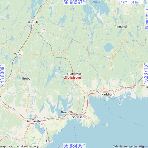
Olofström GPS coordinates[2]
56° 16' 38.28" North, 14° 32' 2.472" East
| Map corner | latitude | longitude |
|---|---|---|
| Upper-left | 56.66567°, | 13.8309° |
| Center: | 56.2773°, | 14.53402° |
| Lower-right: | 55.88495°, | 15.23715° |
| Map W x H: | 86.8×86.8 km | = 53.9×53.9mi |
| max Lat: | 67.85572° ⇑86.6% North |
| Olofström: | 56.2773° |
| min Lat: | ⇓13.4% South 55.34337° |
| min Long | Olofström | max Long |
| 11.1712° | 14.53402° | 24.13676° |
| W 43.5%⇐ | ⇒56.5% E |
Elevation
Elevation of Olofström is 44 m = 144 ft, and this is 38.6 m = 127 ft below average elevation for this country.
| Max E: |
663 m = 2175 ft | 53.8% |
| Avg. | 82.6 m = 271 ft | |
| Olofström | 44 m = 144 ft | |
Min E: |
-1 m = -3 ft | 46.2% |
See also: Sweden elevation on elevation.city.
Geographical zone
Olofström is located in North temperate zone (between Tropic of Cancer and the Arctic Circle). Distance of this North polar circle is 1143.7 km =710.7 mi to North.| Distance of | km | miles | from Olofström |
|---|---|---|---|
| North Pole | 3749.6 | 2329.9 | to North |
| Arctic Circle | 1143.7 | 710.7 | to North |
| Tropic Cancer | 3651.5 | 2268.9 | to South |
| Equator | 6257.4 | 3888.2 | to South |


Nearby cities:
15 places around Olofström: (largest is in red/bold)
• Arkelstorp
19.2 km =11.9 mi,  231°
231°
• Bromölla
22.8 km =14.2 mi,  190°
190°
• Glimåkra
24.9 km =15.5 mi,  275°
275°
• Jämshög
5 km =3.1 mi, 192°
• Karlshamn
23.5 km =14.6 mi,  120°
120°
• Kyrkhult
8.6 km =5.3 mi,  20°
20°
• Lönsboda
19.1 km =11.9 mi,  315°
315°
• Mörrum
16.2 km =10.1 mi,  125°
125°
• Norje
19.7 km =12.2 mi,  155°
155°
• Näsum
11.4 km =7.1 mi, 191°
• Ryd
23 km =14.3 mi, 23°
• Sibbhult
20.7 km =12.9 mi,  266°
266°
• Svängsta
14.4 km =8.9 mi,  94°
94°
• Tollarp1
19.8 km =12.3 mi, 231°
• Valje
23.9 km =14.9 mi,  178°
178°
Sources, notices
• [Note1] Compared only with cities in Sweden existing in our database
• [Src1] Map data: © OpenStreetMap contributors (CC-BY-SA)
• [Src2] Other city data from geonames.org with taken over terms of usage.
• [Src3] Geographical zone / Annual Mean Temperature by Robert A. Rohde @ Wikipedia
