Kyrkhult geodata
Kyrkhult (Blekinge) is a populated place; located in Sweden in Europe/Stockholm (GMT+2) time zone. With population of 980 people, there are 831 cities with bigger population in this country. Compared to other cities in Sweden, 85.5% of cities are located further ↑North; 55.8% of cities are located further →East and 78.2% of cities have lower elevation than Kyrkhult. Note1


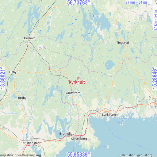
Kyrkhult GPS coordinates[2]
56° 21' 0" North, 14° 34' 59.988" East
| Map corner | latitude | longitude |
|---|---|---|
| Upper-left | 56.73763°, | 13.88021° |
| Center: | 56.35°, | 14.58333° |
| Lower-right: | 55.95839°, | 15.28646° |
| Map W x H: | 86.6×86.6 km | = 53.8×53.8mi |
| max Lat: | 67.85572° ⇑85.5% North |
| Kyrkhult: | 56.35° |
| min Lat: | ⇓14.5% South 55.34337° |
| min Long | Kyrkhult | max Long |
| 11.1712° | 14.58333° | 24.13676° |
| W 44.2%⇐ | ⇒55.8% E |
Elevation
Elevation of Kyrkhult is 135 m = 443 ft, and this is 52.4 m = 172 ft above average elevation for this country.
| Max E: |
663 m = 2175 ft | 21.8% |
| Kyrkhult | 135 m 443 ft | |
| Avg. | 82.6 m = 271 ft | |
Min E: |
-1 m = -3 ft | 78.2% |
See also: Sweden elevation on elevation.city.
Geographical zone
Kyrkhult is located in North temperate zone (between Tropic of Cancer and the Arctic Circle). Distance of this North polar circle is 1135.6 km =705.6 mi to North.| Distance of | km | miles | from Kyrkhult |
|---|---|---|---|
| North Pole | 3741.5 | 2324.9 | to North |
| Arctic Circle | 1135.6 | 705.6 | to North |
| Tropic Cancer | 3659.6 | 2274 | to South |
| Equator | 6265.5 | 3893.2 | to South |


Nearby cities:
15 places around Kyrkhult: (largest is in red/bold)
• Arkelstorp
27 km =16.8 mi,  222°
222°
• Glimåkra
28.3 km =17.6 mi,  258°
258°
• Hällaryd
28.1 km =17.5 mi,  126°
126°
• Jämshög
13.6 km =8.5 mi,  197°
197°
• Karlshamn
26.3 km =16.3 mi,  139°
139°
• Lönsboda
17.3 km =10.7 mi,  288°
288°
• Mörrum
20.2 km =12.6 mi,  149°
149°
• Norje
26.5 km =16.5 mi,  168°
168°
• Näsum
20 km =12.4 mi, 195°
• Olofström
8.6 km =5.3 mi, 200°
• Ryd
14.4 km =8.9 mi,  25°
25°
• Sibbhult
25.4 km =15.8 mi,  248°
248°
• Svängsta
14.6 km =9.1 mi, 129°
• Tollarp1
27.5 km =17.1 mi, 222°
• Urshult
23.8 km =14.8 mi, 31°
Sources, notices
• [Note1] Compared only with cities in Sweden existing in our database
• [Src1] Map data: © OpenStreetMap contributors (CC-BY-SA)
• [Src2] Other city data from geonames.org with taken over terms of usage.
• [Src3] Geographical zone / Annual Mean Temperature by Robert A. Rohde @ Wikipedia
