Ryd geodata
Ryd (Kronoberg) is a populated place; located in Sweden in Europe/Stockholm (GMT+2) time zone. With population of 1,474 people, there are 665 cities with bigger population in this country. Compared to other cities in Sweden, 84.3% of cities are located further ↑North; 54.5% of cities are located further →East and 80.4% of cities have lower elevation than Ryd. Note1


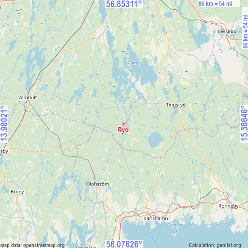
Ryd GPS coordinates[2]
56° 28' 0.012" North, 14° 40' 59.988" East
| Map corner | latitude | longitude |
|---|---|---|
| Upper-left | 56.85311°, | 13.98021° |
| Center: | 56.46667°, | 14.68333° |
| Lower-right: | 56.07626°, | 15.38646° |
| Map W x H: | 86.4×86.4 km | = 53.7×53.7mi |
| max Lat: | 67.85572° ⇑84.3% North |
| Ryd: | 56.46667° |
| min Lat: | ⇓15.7% South 55.34337° |
| min Long | Ryd | max Long |
| 11.1712° | 14.68333° | 24.13676° |
| W 45.5%⇐ | ⇒54.5% E |
Elevation
Elevation of Ryd is 147 m = 482 ft, and this is 64.4 m = 211 ft above average elevation for this country.
| Max E: |
663 m = 2175 ft | 19.6% |
| Ryd | 147 m 482 ft | |
| Avg. | 82.6 m = 271 ft | |
Min E: |
-1 m = -3 ft | 80.4% |
See also: Sweden elevation on elevation.city.
Geographical zone
Ryd is located in North temperate zone (between Tropic of Cancer and the Arctic Circle). Distance of this North polar circle is 1122.7 km =697.6 mi to North.| Distance of | km | miles | from Ryd |
|---|---|---|---|
| North Pole | 3728.6 | 2316.8 | to North |
| Arctic Circle | 1122.7 | 697.6 | to North |
| Tropic Cancer | 3672.6 | 2282 | to South |
| Equator | 6278.5 | 3901.3 | to South |


Nearby cities:
15 places around Ryd: (largest is in red/bold)
• Diö
34.1 km =21.2 mi,  302°
302°
• Grimslöv
31 km =19.3 mi,  342°
342°
• Hällaryd
33.9 km =21.1 mi,  150°
150°
• Ingelstad
34.6 km =21.5 mi,  24°
24°
• Jämshög
27.9 km =17.3 mi,  201°
201°
• Kyrkhult
14.4 km =8.9 mi,  205°
205°
• Liatorp
33.9 km =21.1 mi,  311°
311°
• Lönsboda
23.7 km =14.7 mi,  251°
251°
• Mörrum
30.7 km =19.1 mi,  172°
172°
• Näsum
34.2 km =21.3 mi, 199°
• Olofström
23 km =14.3 mi, 203°
• Svängsta
22.8 km =14.2 mi, 167°
• Tingsryd
19.3 km =12 mi,  70°
70°
• Urshult
9.6 km =6 mi,  39°
39°
• Väckelsång
23.4 km =14.5 mi, 37°
Sources, notices
• [Note1] Compared only with cities in Sweden existing in our database
• [Src1] Map data: © OpenStreetMap contributors (CC-BY-SA)
• [Src2] Other city data from geonames.org with taken over terms of usage.
• [Src3] Geographical zone / Annual Mean Temperature by Robert A. Rohde @ Wikipedia
