Munka-Ljungby geodata
Munka-Ljungby (Skåne) is a populated place; located in Sweden in Europe/Stockholm (GMT+2) time zone. With population of 3,148 people, there are 391 cities with bigger population in this country. Compared to other cities in Sweden, 87.1% of cities are located further ↑North; 80.8% of cities are located further →East and 71.8% of cities have higher elevation than Munka-Ljungby. Note1


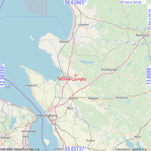
Munka-Ljungby GPS coordinates[2]
56° 15' 0" North, 12° 58' 0.012" East
| Map corner | latitude | longitude |
|---|---|---|
| Upper-left | 56.63865°, | 12.26355° |
| Center: | 56.25°, | 12.96667° |
| Lower-right: | 55.85737°, | 13.6698° |
| Map W x H: | 86.9×86.9 km | = 54×54mi |
| max Lat: | 67.85572° ⇑87.1% North |
| Munka-Ljungby: | 56.25° |
| min Lat: | ⇓12.9% South 55.34337° |
| min Long | Munka-Ljungby | max Long |
| 11.1712° | 12.96667° | 24.13676° |
| W 19.2%⇐ | ⇒80.8% E |
Elevation
Elevation of Munka-Ljungby is 23 m = 75 ft, and this is 59.6 m = 196 ft below average elevation for this country.
| Max E: |
663 m = 2175 ft | 71.8% |
| Avg. | 82.6 m = 271 ft | |
| Munka-Ljungby | 23 m = 75 ft | |
Min E: |
-1 m = -3 ft | 28.2% |
See also: Sweden elevation on elevation.city.
Geographical zone
Munka-Ljungby is located in North temperate zone (between Tropic of Cancer and the Arctic Circle). Distance of this North polar circle is 1146.8 km =712.6 mi to North.| Distance of | km | miles | from Munka-Ljungby |
|---|---|---|---|
| North Pole | 3752.6 | 2331.8 | to North |
| Arctic Circle | 1146.8 | 712.6 | to North |
| Tropic Cancer | 3648.5 | 2267.1 | to South |
| Equator | 6254.4 | 3886.3 | to South |


Nearby cities:
15 places around Munka-Ljungby: (largest is in red/bold)
• Björnås
13.9 km =8.6 mi,  180°
180°
• Förslöv
14.5 km =9 mi,  320°
320°
• Grevie
16.6 km =10.3 mi, 321°
• Hasslarp
16 km =9.9 mi,  215°
215°
• Hjärnarp
8 km =5 mi,  337°
337°
• Kattarp
16.7 km =10.4 mi, 223°
• Klippan
16.3 km =10.1 mi,  141°
141°
• Kvidinge
13.8 km =8.6 mi,  159°
159°
• Skepparkroken
11.3 km =7 mi,  294°
294°
• Stidsvig
11.7 km =7.3 mi,  118°
118°
• Strövelstorp
11.9 km =7.4 mi, 221°
• Vejbystrand
14.4 km =8.9 mi,  301°
301°
• Ängelholm
6.5 km =4 mi,  262°
262°
• Åstorp
12.8 km =8 mi,  186°
186°
• Östra Ljungby
9.8 km =6.1 mi,  127°
127°
Sources, notices
• [Note1] Compared only with cities in Sweden existing in our database
• [Src1] Map data: © OpenStreetMap contributors (CC-BY-SA)
• [Src2] Other city data from geonames.org with taken over terms of usage.
• [Src3] Geographical zone / Annual Mean Temperature by Robert A. Rohde @ Wikipedia
