Östra Ljungby geodata
Östra Ljungby (Skåne) is a populated place; located in Sweden in Europe/Stockholm (GMT+2) time zone. With population of 1,740 people, there are 585 cities with bigger population in this country. Compared to other cities in Sweden, 88.2% of cities are located further ↑North; 77.5% of cities are located further →East and 53% of cities have higher elevation than Östra Ljungby. Note1


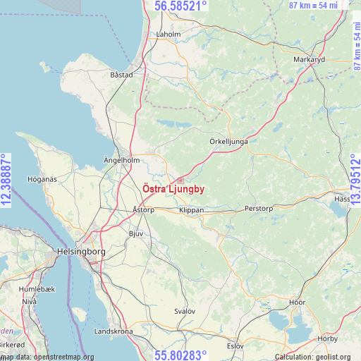
Östra Ljungby GPS coordinates[2]
56° 11' 45.636" North, 13° 5' 31.164" East
| Map corner | latitude | longitude |
|---|---|---|
| Upper-left | 56.58521°, | 12.38887° |
| Center: | 56.19601°, | 13.09199° |
| Lower-right: | 55.80283°, | 13.79512° |
| Map W x H: | 87×87 km | = 54.1×54.1mi |
| max Lat: | 67.85572° ⇑88.2% North |
| Östra Ljungby: | 56.19601° |
| min Lat: | ⇓11.8% South 55.34337° |
| min Long | Östra Ljungby | max Long |
| 11.1712° | 13.09199° | 24.13676° |
| W 22.5%⇐ | ⇒77.5% E |
Elevation
Elevation of Östra Ljungby is 45 m = 148 ft, and this is 37.6 m = 123 ft below average elevation for this country.
| Max E: |
663 m = 2175 ft | 53% |
| Avg. | 82.6 m = 271 ft | |
| Östra Ljungby | 45 m = 148 ft | |
Min E: |
-1 m = -3 ft | 47% |
See also: Sweden elevation on elevation.city.
Geographical zone
Östra Ljungby is located in North temperate zone (between Tropic of Cancer and the Arctic Circle). Distance of this North polar circle is 1152.8 km =716.3 mi to North.| Distance of | km | miles | from Östra Ljungby |
|---|---|---|---|
| North Pole | 3758.7 | 2335.5 | to North |
| Arctic Circle | 1152.8 | 716.3 | to North |
| Tropic Cancer | 3642.5 | 2263.3 | to South |
| Equator | 6248.4 | 3882.6 | to South |


Nearby cities:
15 places around Östra Ljungby: (largest is in red/bold)
• Billesholm
17.2 km =10.7 mi,  199°
199°
• Bjuv
16.4 km =10.2 mi,  220°
220°
• Björnås
11.2 km =7 mi, 224°
• Hasslarp
18.4 km =11.4 mi,  247°
247°
• Hjärnarp
17.2 km =10.7 mi,  321°
321°
• Hyllinge
18.4 km =11.4 mi,  234°
234°
• Klippan
7.1 km =4.4 mi,  160°
160°
• Kvidinge
7.5 km =4.7 mi, 202°
• Ljungbyhed
16.3 km =10.1 mi,  145°
145°
• Munka-Ljungby
9.8 km =6.1 mi,  307°
307°
• Stidsvig
2.6 km =1.6 mi,  80°
80°
• Strövelstorp
15.9 km =9.9 mi,  259°
259°
• Ängelholm
15.1 km =9.4 mi,  290°
290°
• Åstorp
11.3 km =7 mi, 233°
• Örkelljunga
15 km =9.3 mi,  49°
49°
Sources, notices
• [Note1] Compared only with cities in Sweden existing in our database
• [Src1] Map data: © OpenStreetMap contributors (CC-BY-SA)
• [Src2] Other city data from geonames.org with taken over terms of usage.
• [Src3] Geographical zone / Annual Mean Temperature by Robert A. Rohde @ Wikipedia
