Björnås geodata
Björnås (Skåne) is a populated place; located in Sweden in Europe/Stockholm (GMT+2) time zone. With population of 808 people, there are 960 cities with bigger population in this country. Compared to other cities in Sweden, 90% of cities are located further ↑North; 80.9% of cities are located further →East and 65.3% of cities have lower elevation than Björnås. Note1


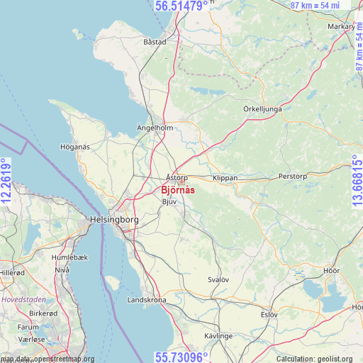
Björnås GPS coordinates[2]
56° 7' 29.532" North, 12° 57' 54.072" East
| Map corner | latitude | longitude |
|---|---|---|
| Upper-left | 56.51479°, | 12.2619° |
| Center: | 56.12487°, | 12.96502° |
| Lower-right: | 55.73096°, | 13.66815° |
| Map W x H: | 87.2×87.2 km | = 54.2×54.2mi |
| max Lat: | 67.85572° ⇑90% North |
| Björnås: | 56.12487° |
| min Lat: | ⇓10% South 55.34337° |
| min Long | Björnås | max Long |
| 11.1712° | 12.96502° | 24.13676° |
| W 19.1%⇐ | ⇒80.9% E |
Elevation
Elevation of Björnås is 84 m = 276 ft, and this is 1.4 m = 5 ft above average elevation for this country.
| Max E: |
663 m = 2175 ft | 34.7% |
| Björnås | 84 m 276 ft | |
| Avg. | 82.6 m = 271 ft | |
Min E: |
-1 m = -3 ft | 65.3% |
See also: Sweden elevation on elevation.city.
Geographical zone
Björnås is located in North temperate zone (between Tropic of Cancer and the Arctic Circle). Distance of this North polar circle is 1160.7 km =721.2 mi to North.| Distance of | km | miles | from Björnås |
|---|---|---|---|
| North Pole | 3766.6 | 2340.5 | to North |
| Arctic Circle | 1160.7 | 721.2 | to North |
| Tropic Cancer | 3634.6 | 2258.4 | to South |
| Equator | 6240.5 | 3877.7 | to South |


Nearby cities:
15 places around Björnås: (largest is in red/bold)
• Billesholm
8.6 km =5.3 mi,  165°
165°
• Bjuv
5.4 km =3.4 mi,  211°
211°
• Hasslarp
9.2 km =5.7 mi,  275°
275°
• Hyllinge
7.6 km =4.7 mi,  248°
248°
• Kattarp
11.4 km =7.1 mi, 278°
• Klippan
10.3 km =6.4 mi,  83°
83°
• Kvidinge
5.2 km =3.2 mi, 78°
• Munka-Ljungby
13.9 km =8.6 mi,  0°
0°
• Mörarp
9.2 km =5.7 mi,  215°
215°
• Påarp
13.7 km =8.5 mi, 222°
• Stidsvig
13.4 km =8.3 mi,  51°
51°
• Strövelstorp
9.3 km =5.8 mi,  302°
302°
• Åstorp
1.8 km =1.1 mi,  313°
313°
• Ödåkra
13.7 km =8.5 mi,  260°
260°
• Östra Ljungby
11.2 km =7 mi,  44°
44°
Sources, notices
• [Note1] Compared only with cities in Sweden existing in our database
• [Src1] Map data: © OpenStreetMap contributors (CC-BY-SA)
• [Src2] Other city data from geonames.org with taken over terms of usage.
• [Src3] Geographical zone / Annual Mean Temperature by Robert A. Rohde @ Wikipedia
