Figeholm geodata
Figeholm (Kalmar) is a populated place; located in Sweden in Europe/Stockholm (GMT+2) time zone. With population of 730 people, there are 1032 cities with bigger population in this country. Compared to other cities in Sweden, 73.7% of cities are located further ↑North; 69.1% of cities are located further ←West and 87.5% of cities have higher elevation than Figeholm. Note1


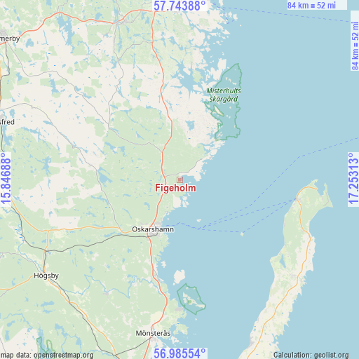
Figeholm GPS coordinates[2]
57° 22' 0.012" North, 16° 33' 0" East
| Map corner | latitude | longitude |
|---|---|---|
| Upper-left | 57.74388°, | 15.84688° |
| Center: | 57.36667°, | 16.55° |
| Lower-right: | 56.98554°, | 17.25313° |
| Map W x H: | 84.3×84.3 km | = 52.4×52.4mi |
| max Lat: | 67.85572° ⇑73.7% North |
| Figeholm: | 57.36667° |
| min Lat: | ⇓26.3% South 55.34337° |
| min Long | Figeholm | max Long |
| 11.1712° | 16.55° | 24.13676° |
| W 69.1%⇐ | ⇒30.9% E |
Elevation
Elevation of Figeholm is 11 m = 36 ft, and this is 71.6 m = 235 ft below average elevation for this country.
| Max E: |
663 m = 2175 ft | 87.5% |
| Avg. | 82.6 m = 271 ft | |
| Figeholm | 11 m = 36 ft | |
Min E: |
-1 m = -3 ft | 12.5% |
See also: Sweden elevation on elevation.city.
Geographical zone
Figeholm is located in North temperate zone (between Tropic of Cancer and the Arctic Circle). Distance of this North polar circle is 1022.6 km =635.4 mi to North.| Distance of | km | miles | from Figeholm |
|---|---|---|---|
| North Pole | 3628.5 | 2254.6 | to North |
| Arctic Circle | 1022.6 | 635.4 | to North |
| Tropic Cancer | 3772.7 | 2344.2 | to South |
| Equator | 6378.6 | 3963.5 | to South |


Nearby cities:
15 places around Figeholm: (largest is in red/bold)
• Ankarsrum
39.1 km =24.3 mi,  340°
340°
• Berga
35.2 km =21.9 mi,  241°
241°
• Blomstermåla
44.6 km =27.7 mi,  197°
197°
• Fliseryd
31 km =19.3 mi,  213°
213°
• Gunnebo
38.9 km =24.2 mi,  358°
358°
• Hultsfred
44.4 km =27.6 mi,  287°
287°
• Högsby
38.6 km =24 mi,  234°
234°
• Kristdala
21 km =13 mi,  280°
280°
• Löttorp
34.3 km =21.3 mi,  130°
130°
• Mönsterås
36.7 km =22.8 mi,  189°
189°
• Mörlunda
42.4 km =26.3 mi,  262°
262°
• Oskarshamn
12.9 km =8 mi, 208°
• Påskallavik
23 km =14.3 mi, 195°
• Ruda
38.8 km =24.1 mi,  222°
222°
• Västervik
43.9 km =27.3 mi,  6°
6°
Sources, notices
• [Note1] Compared only with cities in Sweden existing in our database
• [Src1] Map data: © OpenStreetMap contributors (CC-BY-SA)
• [Src2] Other city data from geonames.org with taken over terms of usage.
• [Src3] Geographical zone / Annual Mean Temperature by Robert A. Rohde @ Wikipedia
