Kolbäck geodata
Kolbäck (Västmanland) is a populated place; located in Sweden in Europe/Stockholm (GMT+2) time zone. With population of 2,034 people, there are 515 cities with bigger population in this country. Compared to other cities in Sweden, 67.5% of cities are located further ↓South; 64.6% of cities are located further ←West and 70.9% of cities have higher elevation than Kolbäck. Note1
Administrative division(s):
- Level 1: Västmanland
- Level 2: Hallstahammars Kommun
- Level 3: Kolbäck-Säby
- Level 4: Kolbäck socken


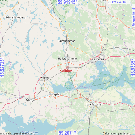
Kolbäck GPS coordinates[2]
59° 33' 54.576" North, 16° 13' 49.332" East
| Map corner | latitude | longitude |
|---|---|---|
| Upper-left | 59.91945°, | 15.52725° |
| Center: | 59.56516°, | 16.23037° |
| Lower-right: | 59.2071°, | 16.9335° |
| Map W x H: | 79.2×79.2 km | = 49.2×49.2mi |
| max Lat: | 67.85572° ⇑32.5% North |
| Kolbäck: | 59.56516° |
| min Lat: | ⇓67.5% South 55.34337° |
| min Long | Kolbäck | max Long |
| 11.1712° | 16.23037° | 24.13676° |
| W 64.6%⇐ | ⇒35.4% E |
Elevation
Elevation of Kolbäck is 24 m = 79 ft, and this is 58.6 m = 192 ft below average elevation for this country.
| Max E: |
663 m = 2175 ft | 70.9% |
| Avg. | 82.6 m = 271 ft | |
| Kolbäck | 24 m = 79 ft | |
Min E: |
-1 m = -3 ft | 29.1% |
See also: Sweden elevation on elevation.city.
Geographical zone
Kolbäck is located in North temperate zone (between Tropic of Cancer and the Arctic Circle). Distance of this North polar circle is 778.1 km =483.5 mi to North.| Distance of | km | miles | from Kolbäck |
|---|---|---|---|
| North Pole | 3384 | 2102.7 | to North |
| Arctic Circle | 778.1 | 483.5 | to North |
| Tropic Cancer | 4017.1 | 2496.1 | to South |
| Equator | 6623 | 4115.3 | to South |


Nearby cities:
15 places around Kolbäck: (largest is in red/bold)
• Barkarö
15.7 km =9.8 mi,  96°
96°
• Dingtuna
8.9 km =5.5 mi,  84°
84°
• Enhagen-Ekbacken
16.9 km =10.5 mi,  89°
89°
• Hallstahammar
5.4 km =3.4 mi,  358°
358°
• Horn
7.8 km =4.8 mi,  157°
157°
• Kungsör
17.6 km =10.9 mi,  205°
205°
• Kvicksund
13.7 km =8.5 mi, 157°
• Köping
14.6 km =9.1 mi,  247°
247°
• Skillinge
16.9 km =10.5 mi,  202°
202°
• Skultuna
19.8 km =12.3 mi,  31°
31°
• Strömsholm
4.3 km =2.7 mi,  170°
170°
• Surahammar
15.8 km =9.8 mi, 358°
• Sylta
14.4 km =8.9 mi,  255°
255°
• Torshälla
21.2 km =13.2 mi,  141°
141°
• Västerås
19 km =11.8 mi,  72°
72°
Sources, notices
• [Note1] Compared only with cities in Sweden existing in our database
• [Src1] Map data: © OpenStreetMap contributors (CC-BY-SA)
• [Src2] Other city data from geonames.org with taken over terms of usage.
• [Src3] Geographical zone / Annual Mean Temperature by Robert A. Rohde @ Wikipedia
