Surahammar geodata
Surahammar (Västmanland) is a seat of a second-order administrative division; located in Sweden in Europe/Stockholm (GMT+2) time zone. With population of 6,270 people, there are 226 cities with bigger population in this country. Compared to other cities in Sweden, 69.9% of cities are located further ↓South; 64.5% of cities are located further ←West and 60.4% of cities have lower elevation than Surahammar. Note1


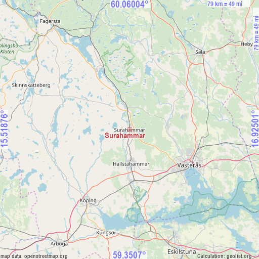
Surahammar GPS coordinates[2]
59° 42' 26.1" North, 16° 13' 18.768" East
| Map corner | latitude | longitude |
|---|---|---|
| Upper-left | 60.06004°, | 15.51876° |
| Center: | 59.70725°, | 16.22188° |
| Lower-right: | 59.3507°, | 16.92501° |
| Map W x H: | 78.9×78.9 km | = 49×49mi |
| max Lat: | 67.85572° ⇑30.1% North |
| Surahammar: | 59.70725° |
| min Lat: | ⇓69.9% South 55.34337° |
| min Long | Surahammar | max Long |
| 11.1712° | 16.22188° | 24.13676° |
| W 64.5%⇐ | ⇒35.5% E |
Elevation
Elevation of Surahammar is 72 m = 236 ft, and this is 10.6 m = 35 ft below average elevation for this country.
| Max E: |
663 m = 2175 ft | 39.6% |
| Avg. | 82.6 m = 271 ft | |
| Surahammar | 72 m = 236 ft | |
Min E: |
-1 m = -3 ft | 60.4% |
See also: Sweden elevation on elevation.city.
Geographical zone
Surahammar is located in North temperate zone (between Tropic of Cancer and the Arctic Circle). Distance of this North polar circle is 762.4 km =473.7 mi to North.| Distance of | km | miles | from Surahammar |
|---|---|---|---|
| North Pole | 3368.2 | 2092.9 | to North |
| Arctic Circle | 762.4 | 473.7 | to North |
| Tropic Cancer | 4032.9 | 2505.9 | to South |
| Equator | 6638.8 | 4125.2 | to South |


Nearby cities:
15 places around Surahammar: (largest is in red/bold)
• Barkarö
23.8 km =14.8 mi,  137°
137°
• Dingtuna
17.6 km =10.9 mi,  148°
148°
• Enhagen-Ekbacken
23.4 km =14.5 mi,  132°
132°
• Hallstahammar
10.4 km =6.5 mi,  177°
177°
• Horn
23.3 km =14.5 mi,  171°
171°
• Hökåsen
20.8 km =12.9 mi,  102°
102°
• Kolbäck
15.8 km =9.8 mi, 178°
• Kolsva
24.9 km =15.5 mi,  241°
241°
• Köping
25.1 km =15.6 mi,  210°
210°
• Ramnäs
6.7 km =4.2 mi,  349°
349°
• Skultuna
11 km =6.8 mi,  84°
84°
• Strömsholm
20.1 km =12.5 mi, 176°
• Sylta
23.5 km =14.6 mi, 214°
• Tillberga
22.3 km =13.9 mi, 96°
• Västerås
21.2 km =13.2 mi,  118°
118°
Sources, notices
• [Note1] Compared only with cities in Sweden existing in our database
• [Src1] Map data: © OpenStreetMap contributors (CC-BY-SA)
• [Src2] Other city data from geonames.org with taken over terms of usage.
• [Src3] Geographical zone / Annual Mean Temperature by Robert A. Rohde @ Wikipedia
