Hallstahammar geodata
Hallstahammar (Västmanland) is a seat of a second-order administrative division; located in Sweden in Europe/Stockholm (GMT+2) time zone. With population of 10,787 people, there are 140 cities with bigger population in this country. Compared to other cities in Sweden, 68.5% of cities are located further ↓South; 64.5% of cities are located further ←West and 60.3% of cities have higher elevation than Hallstahammar. Note1


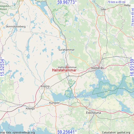
Hallstahammar GPS coordinates[2]
59° 36' 50.22" North, 16° 13' 42.456" East
| Map corner | latitude | longitude |
|---|---|---|
| Upper-left | 59.96773°, | 15.52534° |
| Center: | 59.61395°, | 16.22846° |
| Lower-right: | 59.25641°, | 16.93159° |
| Map W x H: | 79.1×79.1 km | = 49.2×49.2mi |
| max Lat: | 67.85572° ⇑31.5% North |
| Hallstahammar: | 59.61395° |
| min Lat: | ⇓68.5% South 55.34337° |
| min Long | Hallstahammar | max Long |
| 11.1712° | 16.22846° | 24.13676° |
| W 64.5%⇐ | ⇒35.5% E |
Elevation
Elevation of Hallstahammar is 35 m = 115 ft, and this is 47.6 m = 156 ft below average elevation for this country.
| Max E: |
663 m = 2175 ft | 60.3% |
| Avg. | 82.6 m = 271 ft | |
| Hallstahammar | 35 m = 115 ft | |
Min E: |
-1 m = -3 ft | 39.7% |
See also: Sweden elevation on elevation.city.
Geographical zone
Hallstahammar is located in North temperate zone (between Tropic of Cancer and the Arctic Circle). Distance of this North polar circle is 772.7 km =480.1 mi to North.| Distance of | km | miles | from Hallstahammar |
|---|---|---|---|
| North Pole | 3378.6 | 2099.4 | to North |
| Arctic Circle | 772.7 | 480.1 | to North |
| Tropic Cancer | 4022.5 | 2499.5 | to South |
| Equator | 6628.4 | 4118.7 | to South |


Nearby cities:
15 places around Hallstahammar: (largest is in red/bold)
• Barkarö
17.3 km =10.7 mi,  114°
114°
• Dingtuna
10 km =6.2 mi,  117°
117°
• Enhagen-Ekbacken
17.8 km =11.1 mi, 107°
• Horn
13 km =8.1 mi,  166°
166°
• Hökåsen
20.8 km =12.9 mi,  73°
73°
• Kolbäck
5.4 km =3.4 mi,  178°
178°
• Kvicksund
18.9 km =11.7 mi,  163°
163°
• Köping
17.3 km =10.7 mi,  230°
230°
• Ramnäs
17.1 km =10.6 mi,  354°
354°
• Skillinge
22 km =13.7 mi,  196°
196°
• Skultuna
15.6 km =9.7 mi,  42°
42°
• Strömsholm
9.7 km =6 mi, 175°
• Surahammar
10.4 km =6.5 mi,  357°
357°
• Sylta
16.5 km =10.3 mi,  236°
236°
• Västerås
18.2 km =11.3 mi,  89°
89°
Sources, notices
• [Note1] Compared only with cities in Sweden existing in our database
• [Src1] Map data: © OpenStreetMap contributors (CC-BY-SA)
• [Src2] Other city data from geonames.org with taken over terms of usage.
• [Src3] Geographical zone / Annual Mean Temperature by Robert A. Rohde @ Wikipedia
