Bottnaryd geodata
Bottnaryd (Jönköping) is a populated place; located in Sweden in Europe/Stockholm (GMT+2) time zone. With population of 717 people, there are 1046 cities with bigger population in this country. Compared to other cities in Sweden, 65.1% of cities are located further ↑North; 66.4% of cities are located further →East and 93.2% of cities have lower elevation than Bottnaryd. Note1


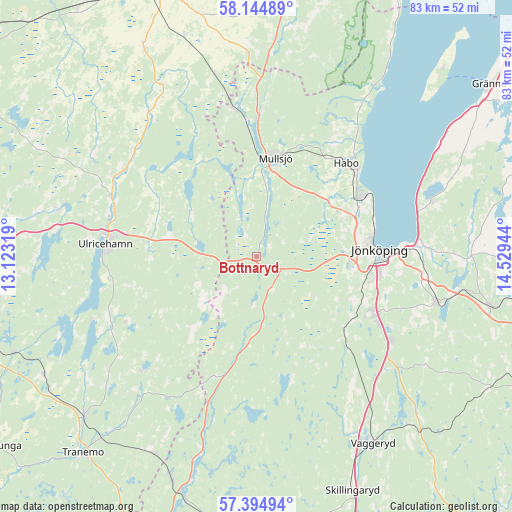
Bottnaryd GPS coordinates[2]
57° 46' 18.696" North, 13° 49' 34.716" East
| Map corner | latitude | longitude |
|---|---|---|
| Upper-left | 58.14489°, | 13.12319° |
| Center: | 57.77186°, | 13.82631° |
| Lower-right: | 57.39494°, | 14.52944° |
| Map W x H: | 83.4×83.4 km | = 51.8×51.8mi |
| max Lat: | 67.85572° ⇑65.1% North |
| Bottnaryd: | 57.77186° |
| min Lat: | ⇓34.9% South 55.34337° |
| min Long | Bottnaryd | max Long |
| 11.1712° | 13.82631° | 24.13676° |
| W 33.6%⇐ | ⇒66.4% E |
Elevation
Elevation of Bottnaryd is 228 m = 748 ft, and this is 145.4 m = 477 ft above average elevation for this country.
| Max E: |
663 m = 2175 ft | 6.8% |
| Bottnaryd | 228 m 748 ft | |
| Avg. | 82.6 m = 271 ft | |
Min E: |
-1 m = -3 ft | 93.2% |
See also: Sweden elevation on elevation.city.
Geographical zone
Bottnaryd is located in North temperate zone (between Tropic of Cancer and the Arctic Circle). Distance of this North polar circle is 977.5 km =607.4 mi to North.| Distance of | km | miles | from Bottnaryd |
|---|---|---|---|
| North Pole | 3583.4 | 2226.6 | to North |
| Arctic Circle | 977.5 | 607.4 | to North |
| Tropic Cancer | 3817.7 | 2372.2 | to South |
| Equator | 6423.6 | 3991.4 | to South |


Nearby cities:
15 places around Bottnaryd: (largest is in red/bold)
• Bankeryd
20.2 km =12.6 mi,  60°
60°
• Barnarp
22.2 km =13.8 mi,  109°
109°
• Blidsberg
27.1 km =16.8 mi,  311°
311°
• Dalstorp
25.9 km =16.1 mi,  223°
223°
• Dalum
25.6 km =15.9 mi,  303°
303°
• Gällstad
26.1 km =16.2 mi,  243°
243°
• Habo
21.4 km =13.3 mi,  43°
43°
• Jönköping
19.6 km =12.2 mi,  86°
86°
• Kortebo
19.8 km =12.3 mi,  75°
75°
• Mullsjö
16.4 km =10.2 mi,  10°
10°
• Odensjö
21.1 km =13.1 mi, 106°
• Sandhem
23.8 km =14.8 mi,  351°
351°
• Taberg
18.8 km =11.7 mi,  124°
124°
• Timmele
25.5 km =15.8 mi,  292°
292°
• Ulricehamn
24.5 km =15.2 mi,  275°
275°
Sources, notices
• [Note1] Compared only with cities in Sweden existing in our database
• [Src1] Map data: © OpenStreetMap contributors (CC-BY-SA)
• [Src2] Other city data from geonames.org with taken over terms of usage.
• [Src3] Geographical zone / Annual Mean Temperature by Robert A. Rohde @ Wikipedia
