Hillared geodata
Hillared (Västra Götaland) is a populated place; located in Sweden in Europe/Stockholm (GMT+2) time zone. With population of 639 people, there are 1135 cities with bigger population in this country. Compared to other cities in Sweden, 69.7% of cities are located further ↑North; 76.1% of cities are located further →East and 89.3% of cities have lower elevation than Hillared. Note1


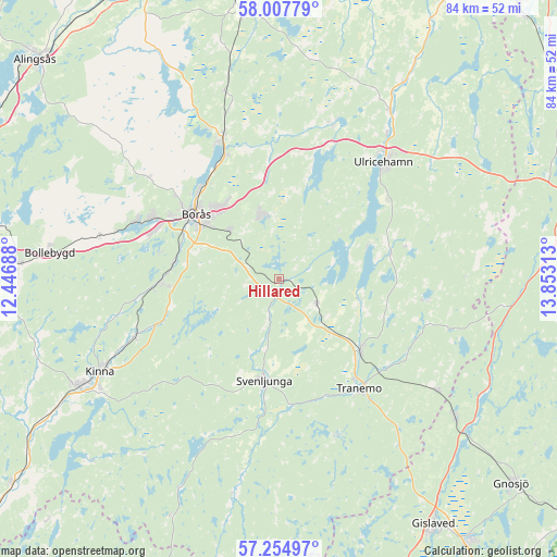
Hillared GPS coordinates[2]
57° 37' 59.988" North, 13° 9' 0" East
| Map corner | latitude | longitude |
|---|---|---|
| Upper-left | 58.00779°, | 12.44688° |
| Center: | 57.63333°, | 13.15° |
| Lower-right: | 57.25497°, | 13.85313° |
| Map W x H: | 83.7×83.7 km | = 52×52mi |
| max Lat: | 67.85572° ⇑69.7% North |
| Hillared: | 57.63333° |
| min Lat: | ⇓30.3% South 55.34337° |
| min Long | Hillared | max Long |
| 11.1712° | 13.15° | 24.13676° |
| W 23.9%⇐ | ⇒76.1% E |
Elevation
Elevation of Hillared is 195 m = 640 ft, and this is 112.4 m = 369 ft above average elevation for this country.
| Max E: |
663 m = 2175 ft | 10.7% |
| Hillared | 195 m 640 ft | |
| Avg. | 82.6 m = 271 ft | |
Min E: |
-1 m = -3 ft | 89.3% |
See also: Sweden elevation on elevation.city.
Geographical zone
Hillared is located in North temperate zone (between Tropic of Cancer and the Arctic Circle). Distance of this North polar circle is 992.9 km =617 mi to North.| Distance of | km | miles | from Hillared |
|---|---|---|---|
| North Pole | 3598.8 | 2236.2 | to North |
| Arctic Circle | 992.9 | 617 | to North |
| Tropic Cancer | 3802.3 | 2362.6 | to South |
| Equator | 6408.2 | 3981.9 | to South |


Nearby cities:
15 places around Hillared: (largest is in red/bold)
• Borås
15.8 km =9.8 mi,  307°
307°
• Dalsjöfors
10.1 km =6.3 mi,  336°
336°
• Frufällan
19.9 km =12.4 mi,  326°
326°
• Gällstad
17.3 km =10.7 mi,  77°
77°
• Gånghester
10.9 km =6.8 mi, 313°
• Limmared
16.4 km =10.2 mi,  131°
131°
• Länghem
6.2 km =3.9 mi, 126°
• Målsryd
8.1 km =5 mi, 313°
• Rydboholm
16 km =9.9 mi,  276°
276°
• Sexdrega
5.9 km =3.7 mi,  199°
199°
• Svaneholm
19.9 km =12.4 mi,  264°
264°
• Svenljunga
15.5 km =9.6 mi,  188°
188°
• Tranemo
20.5 km =12.7 mi,  144°
144°
• Vegby
15 km =9.3 mi,  68°
68°
• Viskafors
17.9 km =11.1 mi,  268°
268°
Sources, notices
• [Note1] Compared only with cities in Sweden existing in our database
• [Src1] Map data: © OpenStreetMap contributors (CC-BY-SA)
• [Src2] Other city data from geonames.org with taken over terms of usage.
• [Src3] Geographical zone / Annual Mean Temperature by Robert A. Rohde @ Wikipedia
