Frufällan geodata
Frufällan (Västra Götaland) is a populated place; located in Sweden in Europe/Stockholm (GMT+2) time zone. With population of 884 people, there are 894 cities with bigger population in this country. Compared to other cities in Sweden, 64.8% of cities are located further ↑North; 80.8% of cities are located further →East and 84.5% of cities have lower elevation than Frufällan. Note1


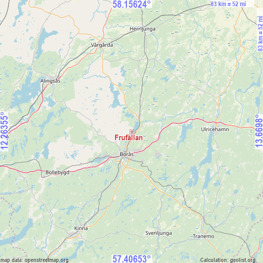
Frufällan GPS coordinates[2]
57° 46' 59.988" North, 12° 58' 0.012" East
| Map corner | latitude | longitude |
|---|---|---|
| Upper-left | 58.15624°, | 12.26355° |
| Center: | 57.78333°, | 12.96667° |
| Lower-right: | 57.40653°, | 13.6698° |
| Map W x H: | 83.4×83.4 km | = 51.8×51.8mi |
| max Lat: | 67.85572° ⇑64.8% North |
| Frufällan: | 57.78333° |
| min Lat: | ⇓35.2% South 55.34337° |
| min Long | Frufällan | max Long |
| 11.1712° | 12.96667° | 24.13676° |
| W 19.2%⇐ | ⇒80.8% E |
Elevation
Elevation of Frufällan is 166 m = 545 ft, and this is 83.4 m = 274 ft above average elevation for this country.
| Max E: |
663 m = 2175 ft | 15.5% |
| Frufällan | 166 m 545 ft | |
| Avg. | 82.6 m = 271 ft | |
Min E: |
-1 m = -3 ft | 84.5% |
See also: Sweden elevation on elevation.city.
Geographical zone
Frufällan is located in North temperate zone (between Tropic of Cancer and the Arctic Circle). Distance of this North polar circle is 976.3 km =606.6 mi to North.| Distance of | km | miles | from Frufällan |
|---|---|---|---|
| North Pole | 3582.2 | 2225.9 | to North |
| Arctic Circle | 976.3 | 606.6 | to North |
| Tropic Cancer | 3819 | 2373 | to South |
| Equator | 6424.9 | 3992.2 | to South |


Nearby cities:
15 places around Frufällan: (largest is in red/bold)
• Borås
7.1 km =4.4 mi,  192°
192°
• Dalsjöfors
10.1 km =6.3 mi,  136°
136°
• Fristad
5.3 km =3.3 mi,  29°
29°
• Gånghester
9.7 km =6 mi,  162°
162°
• Hillared
19.9 km =12.4 mi,  146°
146°
• Hökerum
19.8 km =12.3 mi,  71°
71°
• Ljung
23.2 km =14.4 mi,  13°
13°
• Målsryd
12.2 km =7.6 mi, 156°
• Olsfors
19 km =11.8 mi,  237°
237°
• Rydboholm
15.6 km =9.7 mi,  198°
198°
• Sandared
13.2 km =8.2 mi,  231°
231°
• Sandhult
9.1 km =5.7 mi,  258°
258°
• Sjömarken
10.9 km =6.8 mi, 225°
• Svaneholm
20.6 km =12.8 mi,  205°
205°
• Viskafors
18.5 km =11.5 mi, 202°
Sources, notices
• [Note1] Compared only with cities in Sweden existing in our database
• [Src1] Map data: © OpenStreetMap contributors (CC-BY-SA)
• [Src2] Other city data from geonames.org with taken over terms of usage.
• [Src3] Geographical zone / Annual Mean Temperature by Robert A. Rohde @ Wikipedia
