Borås geodata
Borås (Västra Götaland) is a seat of a second-order administrative division; located in Sweden in Europe/Stockholm (GMT+2) time zone. With population of 71,700 people, there are 17 cities with bigger population in this country. Compared to other cities in Sweden, 66.5% of cities are located further ↑North; 81.6% of cities are located further →East and 79.6% of cities have lower elevation than Borås. Note1


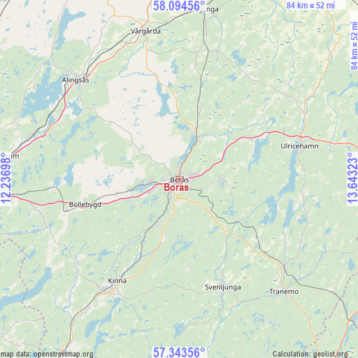
Borås GPS coordinates[2]
57° 43' 15.636" North, 12° 56' 24.36" East
| Map corner | latitude | longitude |
|---|---|---|
| Upper-left | 58.09456°, | 12.23698° |
| Center: | 57.72101°, | 12.9401° |
| Lower-right: | 57.34356°, | 13.64323° |
| Map W x H: | 83.5×83.5 km | = 51.9×51.9mi |
| max Lat: | 67.85572° ⇑66.5% North |
| Borås: | 57.72101° |
| min Lat: | ⇓33.5% South 55.34337° |
| min Long | Borås | max Long |
| 11.1712° | 12.9401° | 24.13676° |
| W 18.4%⇐ | ⇒81.6% E |
Elevation
Elevation of Borås is 143 m = 469 ft, and this is 60.4 m = 198 ft above average elevation for this country.
| Max E: |
663 m = 2175 ft | 20.4% |
| Borås | 143 m 469 ft | |
| Avg. | 82.6 m = 271 ft | |
Min E: |
-1 m = -3 ft | 79.6% |
See also: Borås elevation on elevation.city.
Geographical zone
Borås is located in North temperate zone (between Tropic of Cancer and the Arctic Circle). Distance of this North polar circle is 983.2 km =610.9 mi to North.| Distance of | km | miles | from Borås |
|---|---|---|---|
| North Pole | 3589.1 | 2230.2 | to North |
| Arctic Circle | 983.2 | 610.9 | to North |
| Tropic Cancer | 3812.1 | 2368.7 | to South |
| Equator | 6418 | 3988 | to South |


Nearby cities:
15 places around Borås: (largest is in red/bold)
• Dalsjöfors
8.5 km =5.3 mi,  93°
93°
• Fristad
12.3 km =7.6 mi,  19°
19°
• Fritsla
20.5 km =12.7 mi,  206°
206°
• Frufällan
7.1 km =4.4 mi,  12°
12°
• Gånghester
5.1 km =3.2 mi,  117°
117°
• Hillared
15.8 km =9.8 mi,  127°
127°
• Målsryd
7.8 km =4.8 mi, 122°
• Olsfors
14.8 km =9.2 mi,  256°
256°
• Rydboholm
8.6 km =5.3 mi,  203°
203°
• Sandared
8.9 km =5.5 mi, 261°
• Sandhult
8.9 km =5.5 mi,  304°
304°
• Sexdrega
18.6 km =11.6 mi,  145°
145°
• Sjömarken
6.3 km =3.9 mi, 264°
• Svaneholm
13.7 km =8.5 mi, 212°
• Viskafors
11.5 km =7.1 mi, 208°
Sources, notices
• [Note1] Compared only with cities in Sweden existing in our database
• [Src1] Map data: © OpenStreetMap contributors (CC-BY-SA)
• [Src2] Other city data from geonames.org with taken over terms of usage.
• [Src3] Geographical zone / Annual Mean Temperature by Robert A. Rohde @ Wikipedia
