Hästveda geodata
Hästveda (Skåne) is a populated place; located in Sweden in Europe/Stockholm (GMT+2) time zone. With population of 1,693 people, there are 599 cities with bigger population in this country. Compared to other cities in Sweden, 86.2% of cities are located further ↑North; 65.1% of cities are located further →East and 59.2% of cities have lower elevation than Hästveda. Note1
Administrative division(s):
- Level 1: Skåne
- Level 2: Hässleholms Kommun
- Level 3: Hästveda
- Level 4: Hästveda socken


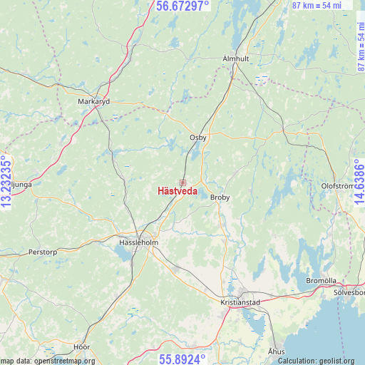
Hästveda GPS coordinates[2]
56° 17' 4.848" North, 13° 56' 7.692" East
| Map corner | latitude | longitude |
|---|---|---|
| Upper-left | 56.67297°, | 13.23235° |
| Center: | 56.28468°, | 13.93547° |
| Lower-right: | 55.8924°, | 14.6386° |
| Map W x H: | 86.8×86.8 km | = 53.9×53.9mi |
| max Lat: | 67.85572° ⇑86.2% North |
| Hästveda: | 56.28468° |
| min Lat: | ⇓13.8% South 55.34337° |
| min Long | Hästveda | max Long |
| 11.1712° | 13.93547° | 24.13676° |
| W 34.9%⇐ | ⇒65.1% E |
Elevation
Elevation of Hästveda is 68 m = 223 ft, and this is 14.6 m = 48 ft below average elevation for this country.
| Max E: |
663 m = 2175 ft | 40.8% |
| Avg. | 82.6 m = 271 ft | |
| Hästveda | 68 m = 223 ft | |
Min E: |
-1 m = -3 ft | 59.2% |
See also: Sweden elevation on elevation.city.
Geographical zone
Hästveda is located in North temperate zone (between Tropic of Cancer and the Arctic Circle). Distance of this North polar circle is 1142.9 km =710.2 mi to North.| Distance of | km | miles | from Hästveda |
|---|---|---|---|
| North Pole | 3748.8 | 2329.4 | to North |
| Arctic Circle | 1142.9 | 710.2 | to North |
| Tropic Cancer | 3652.4 | 2269.5 | to South |
| Equator | 6258.3 | 3888.7 | to South |


Nearby cities:
15 places around Hästveda: (largest is in red/bold)
• Arkelstorp
11.9 km =7.4 mi,  217°
217°
• Bjärnum
13.8 km =8.6 mi,  272°
272°
• Broby
9.4 km =5.8 mi,  110°
110°
• Finja
20.4 km =12.7 mi,  229°
229°
• Glimåkra
12.3 km =7.6 mi,  82°
82°
• Hanaskog
16.9 km =10.5 mi,  144°
144°
• Hittarp
11.2 km =7 mi,  90°
90°
• Hässleholm
17.4 km =10.8 mi, 216°
• Knislinge
14.5 km =9 mi, 140°
• Osby
11.4 km =7.1 mi,  18°
18°
• Sibbhult
16.5 km =10.3 mi,  96°
96°
• Sjörröd
1.2 km =0.7 mi,  262°
262°
• Stoby
13.6 km =8.5 mi,  209°
209°
• Vinslöv
20.6 km =12.8 mi,  183°
183°
• Vittsjö
18.2 km =11.3 mi,  291°
291°
Sources, notices
• [Note1] Compared only with cities in Sweden existing in our database
• [Src1] Map data: © OpenStreetMap contributors (CC-BY-SA)
• [Src2] Other city data from geonames.org with taken over terms of usage.
• [Src3] Geographical zone / Annual Mean Temperature by Robert A. Rohde @ Wikipedia
