Vittsjö geodata
Vittsjö (Skåne) is a populated place; located in Sweden in Europe/Stockholm (GMT+2) time zone. With population of 1,787 people, there are 571 cities with bigger population in this country. Compared to other cities in Sweden, 85.6% of cities are located further ↑North; 68.5% of cities are located further →East and 72.3% of cities have lower elevation than Vittsjö. Note1
Administrative division(s):
- Level 1: Skåne
- Level 2: Hässleholms Kommun
- Level 3: Vittsjö
- Level 4: Vittsjö socken


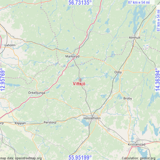
Vittsjö GPS coordinates[2]
56° 20' 37.176" North, 13° 39' 38.916" East
| Map corner | latitude | longitude |
|---|---|---|
| Upper-left | 56.73135°, | 12.95769° |
| Center: | 56.34366°, | 13.66081° |
| Lower-right: | 55.95199°, | 14.36394° |
| Map W x H: | 86.7×86.7 km | = 53.9×53.9mi |
| max Lat: | 67.85572° ⇑85.6% North |
| Vittsjö: | 56.34366° |
| min Lat: | ⇓14.4% South 55.34337° |
| min Long | Vittsjö | max Long |
| 11.1712° | 13.66081° | 24.13676° |
| W 31.5%⇐ | ⇒68.5% E |
Elevation
Elevation of Vittsjö is 107 m = 351 ft, and this is 24.4 m = 80 ft above average elevation for this country.
| Max E: |
663 m = 2175 ft | 27.7% |
| Vittsjö | 107 m 351 ft | |
| Avg. | 82.6 m = 271 ft | |
Min E: |
-1 m = -3 ft | 72.3% |
See also: Sweden elevation on elevation.city.
Geographical zone
Vittsjö is located in North temperate zone (between Tropic of Cancer and the Arctic Circle). Distance of this North polar circle is 1136.3 km =706.1 mi to North.| Distance of | km | miles | from Vittsjö |
|---|---|---|---|
| North Pole | 3742.2 | 2325.3 | to North |
| Arctic Circle | 1136.3 | 706.1 | to North |
| Tropic Cancer | 3658.9 | 2273.5 | to South |
| Equator | 6264.8 | 3892.8 | to South |


Nearby cities:
15 places around Vittsjö: (largest is in red/bold)
• Arkelstorp
18.6 km =11.6 mi,  148°
148°
• Bjärnum
6.7 km =4.2 mi, 152°
• Finja
19.7 km =12.2 mi,  175°
175°
• Hässleholm
21.5 km =13.4 mi,  162°
162°
• Hästveda
18.2 km =11.3 mi,  111°
111°
• Markaryd
13.7 km =8.5 mi,  343°
343°
• Osby
20.9 km =13 mi,  78°
78°
• Sjörröd
17.1 km =10.6 mi, 113°
• Stoby
21.2 km =13.2 mi, 150°
• Strömsnäsbruk
23.2 km =14.4 mi,  8°
8°
• Timsfors
16.2 km =10.1 mi, 342°
• Tormestorp
26.1 km =16.2 mi,  168°
168°
• Tyringe
20.7 km =12.9 mi,  190°
190°
• Åsljunga
18.4 km =11.4 mi,  260°
260°
• Örkelljunga
24.6 km =15.3 mi,  254°
254°
Sources, notices
• [Note1] Compared only with cities in Sweden existing in our database
• [Src1] Map data: © OpenStreetMap contributors (CC-BY-SA)
• [Src2] Other city data from geonames.org with taken over terms of usage.
• [Src3] Geographical zone / Annual Mean Temperature by Robert A. Rohde @ Wikipedia
