Hökåsen geodata
Hökåsen (Västmanland) is a populated place; located in Sweden in Europe/Stockholm (GMT+2) time zone. With population of 2,986 people, there are 406 cities with bigger population in this country. Compared to other cities in Sweden, 69.4% of cities are located further ↓South; 69.7% of cities are located further ←West and 54.9% of cities have lower elevation than Hökåsen. Note1


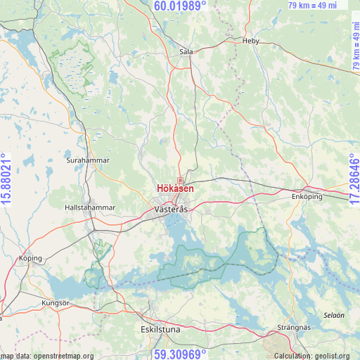
Hökåsen GPS coordinates[2]
59° 40' 0.012" North, 16° 34' 59.988" East
| Map corner | latitude | longitude |
|---|---|---|
| Upper-left | 60.01989°, | 15.88021° |
| Center: | 59.66667°, | 16.58333° |
| Lower-right: | 59.30969°, | 17.28646° |
| Map W x H: | 79×79 km | = 49.1×49.1mi |
| max Lat: | 67.85572° ⇑30.6% North |
| Hökåsen: | 59.66667° |
| min Lat: | ⇓69.4% South 55.34337° |
| min Long | Hökåsen | max Long |
| 11.1712° | 16.58333° | 24.13676° |
| W 69.7%⇐ | ⇒30.3% E |
Elevation
Elevation of Hökåsen is 59 m = 194 ft, and this is 23.6 m = 77 ft below average elevation for this country.
| Max E: |
663 m = 2175 ft | 45.1% |
| Avg. | 82.6 m = 271 ft | |
| Hökåsen | 59 m = 194 ft | |
Min E: |
-1 m = -3 ft | 54.9% |
See also: Sweden elevation on elevation.city.
Geographical zone
Hökåsen is located in North temperate zone (between Tropic of Cancer and the Arctic Circle). Distance of this North polar circle is 766.9 km =476.5 mi to North.| Distance of | km | miles | from Hökåsen |
|---|---|---|---|
| North Pole | 3372.8 | 2095.8 | to North |
| Arctic Circle | 766.9 | 476.5 | to North |
| Tropic Cancer | 4028.4 | 2503.1 | to South |
| Equator | 6634.3 | 4122.4 | to South |


Nearby cities:
15 places around Hökåsen: (largest is in red/bold)
• Barkarö
13.7 km =8.5 mi,  198°
198°
• Dingtuna
15.2 km =9.4 mi,  226°
226°
• Enhagen-Ekbacken
11.6 km =7.2 mi,  194°
194°
• Fjärdhundra
22.5 km =14 mi,  57°
57°
• Hallstahammar
20.8 km =12.9 mi,  253°
253°
• Hummelsta
20.7 km =12.9 mi,  102°
102°
• Irsta
9.9 km =6.2 mi,  138°
138°
• Irsta
20 km =12.4 mi,  79°
79°
• Kolbäck
22.8 km =14.2 mi,  240°
240°
• Ramnäs
24.2 km =15 mi,  297°
297°
• Ransta
16.3 km =10.1 mi,  10°
10°
• Skultuna
10.9 km =6.8 mi, 300°
• Surahammar
20.8 km =12.9 mi,  282°
282°
• Tillberga
2.6 km =1.6 mi,  45°
45°
• Västerås
5.9 km =3.7 mi, 197°
Sources, notices
• [Note1] Compared only with cities in Sweden existing in our database
• [Src1] Map data: © OpenStreetMap contributors (CC-BY-SA)
• [Src2] Other city data from geonames.org with taken over terms of usage.
• [Src3] Geographical zone / Annual Mean Temperature by Robert A. Rohde @ Wikipedia
