Hällbybrunn geodata
Hällbybrunn (Södermanland) is a populated place; located in Sweden in Europe/Stockholm (GMT+2) time zone. With population of 3,323 people, there are 375 cities with bigger population in this country. Compared to other cities in Sweden, 63.2% of cities are located further ↓South; 67.4% of cities are located further ←West and 56% of cities have higher elevation than Hällbybrunn. Note1
Administrative division(s):
- Level 1: Södermanland
- Level 2: Eskilstuna Kommun
- Level 3: Torshälla
- Level 4: Torshälla socken


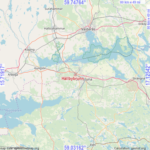
Hällbybrunn GPS coordinates[2]
59° 23' 29.472" North, 16° 25' 20.244" East
| Map corner | latitude | longitude |
|---|---|---|
| Upper-left | 59.74764°, | 15.71917° |
| Center: | 59.39152°, | 16.42229° |
| Lower-right: | 59.03162°, | 17.12542° |
| Map W x H: | 79.6×79.6 km | = 49.5×49.5mi |
| max Lat: | 67.85572° ⇑36.8% North |
| Hällbybrunn: | 59.39152° |
| min Lat: | ⇓63.2% South 55.34337° |
| min Long | Hällbybrunn | max Long |
| 11.1712° | 16.42229° | 24.13676° |
| W 67.4%⇐ | ⇒32.6% E |
Elevation
Elevation of Hällbybrunn is 41 m = 135 ft, and this is 41.6 m = 136 ft below average elevation for this country.
| Max E: |
663 m = 2175 ft | 56% |
| Avg. | 82.6 m = 271 ft | |
| Hällbybrunn | 41 m = 135 ft | |
Min E: |
-1 m = -3 ft | 44% |
See also: Sweden elevation on elevation.city.
Geographical zone
Hällbybrunn is located in North temperate zone (between Tropic of Cancer and the Arctic Circle). Distance of this North polar circle is 797.5 km =495.5 mi to North.| Distance of | km | miles | from Hällbybrunn |
|---|---|---|---|
| North Pole | 3403.3 | 2114.7 | to North |
| Arctic Circle | 797.5 | 495.5 | to North |
| Tropic Cancer | 3997.8 | 2484.1 | to South |
| Equator | 6603.7 | 4103.3 | to South |


Nearby cities:
15 places around Hällbybrunn: (largest is in red/bold)
• Barkarö
18.2 km =11.3 mi,  15°
15°
• Dingtuna
20.3 km =12.6 mi,  354°
354°
• Enhagen-Ekbacken
20.3 km =12.6 mi, 17°
• Eskilstuna
5.6 km =3.5 mi,  119°
119°
• Horn
14.4 km =8.9 mi,  326°
326°
• Hällberga
13.1 km =8.1 mi,  129°
129°
• Hållsta
10.9 km =6.8 mi,  170°
170°
• Kjulaås
13.9 km =8.6 mi,  93°
93°
• Kungsör
18.8 km =11.7 mi,  280°
280°
• Kvicksund
8.7 km =5.4 mi,  319°
319°
• Skillinge
17.6 km =10.9 mi, 281°
• Skogstorp
8.2 km =5.1 mi,  155°
155°
• Strömsholm
18.2 km =11.3 mi, 326°
• Torshälla
3.8 km =2.4 mi,  41°
41°
• Ärla
19.1 km =11.9 mi, 130°
Sources, notices
• [Note1] Compared only with cities in Sweden existing in our database
• [Src1] Map data: © OpenStreetMap contributors (CC-BY-SA)
• [Src2] Other city data from geonames.org with taken over terms of usage.
• [Src3] Geographical zone / Annual Mean Temperature by Robert A. Rohde @ Wikipedia
