Kjulaås geodata
Kjulaås (Södermanland) is a populated place; located in Sweden in Europe/Stockholm (GMT+2) time zone. With population of 915 people, there are 873 cities with bigger population in this country. Compared to other cities in Sweden, 63.1% of cities are located further ↓South; 71.2% of cities are located further ←West and 65.3% of cities have higher elevation than Kjulaås. Note1


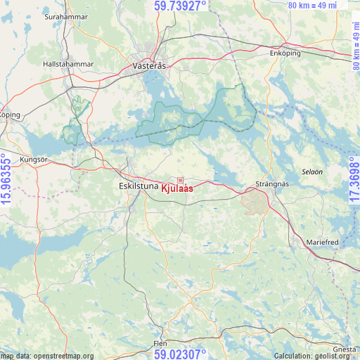
Kjulaås GPS coordinates[2]
59° 22' 59.016" North, 16° 40' 0.012" East
| Map corner | latitude | longitude |
|---|---|---|
| Upper-left | 59.73927°, | 15.96355° |
| Center: | 59.38306°, | 16.66667° |
| Lower-right: | 59.02307°, | 17.3698° |
| Map W x H: | 79.6×79.6 km | = 49.5×49.5mi |
| max Lat: | 67.85572° ⇑36.9% North |
| Kjulaås: | 59.38306° |
| min Lat: | ⇓63.1% South 55.34337° |
| min Long | Kjulaås | max Long |
| 11.1712° | 16.66667° | 24.13676° |
| W 71.2%⇐ | ⇒28.8% E |
Elevation
Elevation of Kjulaås is 30 m = 98 ft, and this is 52.6 m = 173 ft below average elevation for this country.
| Max E: |
663 m = 2175 ft | 65.3% |
| Avg. | 82.6 m = 271 ft | |
| Kjulaås | 30 m = 98 ft | |
Min E: |
-1 m = -3 ft | 34.7% |
See also: Sweden elevation on elevation.city.
Geographical zone
Kjulaås is located in North temperate zone (between Tropic of Cancer and the Arctic Circle). Distance of this North polar circle is 798.4 km =496.1 mi to North.| Distance of | km | miles | from Kjulaås |
|---|---|---|---|
| North Pole | 3404.3 | 2115.3 | to North |
| Arctic Circle | 798.4 | 496.1 | to North |
| Tropic Cancer | 3996.9 | 2483.6 | to South |
| Equator | 6602.8 | 4102.8 | to South |


Nearby cities:
15 places around Kjulaås: (largest is in red/bold)
• Barkarö
20.6 km =12.8 mi,  334°
334°
• Dingtuna
26.3 km =16.3 mi,  323°
323°
• Enhagen-Ekbacken
21.7 km =13.5 mi,  339°
339°
• Eskilstuna
9.2 km =5.7 mi,  258°
258°
• Horn
25.3 km =15.7 mi,  300°
300°
• Hällberga
8.3 km =5.2 mi,  207°
207°
• Hällbybrunn
13.9 km =8.6 mi,  273°
273°
• Härad
13.6 km =8.5 mi,  100°
100°
• Hållsta
15.5 km =9.6 mi,  230°
230°
• Irsta
24.2 km =15 mi,  4°
4°
• Kvicksund
20.9 km =13 mi,  291°
291°
• Skogstorp
12.3 km =7.6 mi,  238°
238°
• Strängnäs
20.7 km =12.9 mi,  91°
91°
• Torshälla
11.9 km =7.4 mi, 288°
• Ärla
11.5 km =7.1 mi,  176°
176°
Sources, notices
• [Note1] Compared only with cities in Sweden existing in our database
• [Src1] Map data: © OpenStreetMap contributors (CC-BY-SA)
• [Src2] Other city data from geonames.org with taken over terms of usage.
• [Src3] Geographical zone / Annual Mean Temperature by Robert A. Rohde @ Wikipedia
