Ärla geodata
Ärla (Södermanland) is a populated place; located in Sweden in Europe/Stockholm (GMT+1) time zone. With population of 1,272 people, there are 720 cities with bigger population in this country. Compared to other cities in Sweden, 59.1% of cities are located further ↓South; 71.2% of cities are located further ←West and 50.2% of cities have higher elevation than Ärla. Note1
Administrative division(s):
- Level 1: Södermanland
- Level 2: Eskilstuna Kommun
- Level 3: Stenkvista-Ärla
- Level 4: Ärla socken


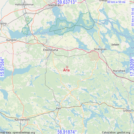
Ärla GPS coordinates[2]
59° 16' 47.388" North, 16° 40' 44.256" East
| Map corner | latitude | longitude |
|---|---|---|
| Upper-left | 59.63713°, | 15.97584° |
| Center: | 59.27983°, | 16.67896° |
| Lower-right: | 58.91874°, | 17.38209° |
| Map W x H: | 79.9×79.9 km | = 49.6×49.6mi |
| max Lat: | 67.85572° ⇑40.9% North |
| Ärla: | 59.27983° |
| min Lat: | ⇓59.1% South 55.34337° |
| min Long | Ärla | max Long |
| 11.1712° | 16.67896° | 24.13676° |
| W 71.2%⇐ | ⇒28.8% E |
Elevation
Elevation of Ärla is 50 m = 164 ft, and this is 32.6 m = 107 ft below average elevation for this country.
| Max E: |
663 m = 2175 ft | 50.2% |
| Avg. | 82.6 m = 271 ft | |
| Ärla | 50 m = 164 ft | |
Min E: |
-1 m = -3 ft | 49.8% |
See also: Sweden elevation on elevation.city.
Geographical zone
Ärla is located in North temperate zone (between Tropic of Cancer and the Arctic Circle). Distance of this North polar circle is 809.9 km =503.2 mi to North.| Distance of | km | miles | from Ärla |
|---|---|---|---|
| North Pole | 3415.8 | 2122.5 | to North |
| Arctic Circle | 809.9 | 503.2 | to North |
| Tropic Cancer | 3985.4 | 2476.4 | to South |
| Equator | 6591.3 | 4095.6 | to South |


Nearby cities:
15 places around Ärla: (largest is in red/bold)
• Eskilstuna
13.7 km =8.5 mi,  314°
314°
• Flen
25.2 km =15.7 mi,  191°
191°
• Hällberga
6.1 km =3.8 mi, 312°
• Hällbybrunn
19.1 km =11.9 mi, 310°
• Hälleforsnäs
17.6 km =10.9 mi,  216°
216°
• Härad
15.6 km =9.7 mi,  54°
54°
• Hållsta
12.9 km =8 mi,  277°
277°
• Kjulaås
11.5 km =7.1 mi,  356°
356°
• Malmköping
16.6 km =10.3 mi,  169°
169°
• Mellösa
21.3 km =13.2 mi,  200°
200°
• Skogstorp
12.2 km =7.6 mi,  294°
294°
• Sparreholm
25 km =15.5 mi,  161°
161°
• Strängnäs
22.7 km =14.1 mi,  61°
61°
• Torshälla
19.4 km =12.1 mi,  321°
321°
• Åkers Styckebruk
23.2 km =14.4 mi,  98°
98°
Sources, notices
• [Note1] Compared only with cities in Sweden existing in our database
• [Src1] Map data: © OpenStreetMap contributors (CC-BY-SA)
• [Src2] Other city data from geonames.org with taken over terms of usage.
• [Src3] Geographical zone / Annual Mean Temperature by Robert A. Rohde @ Wikipedia
