Bräcke geodata
Bräcke (Jämtland) is a seat of a second-order administrative division; located in Sweden in Europe/Stockholm (GMT+2) time zone. With population of 1,559 people, there are 640 cities with bigger population in this country. Compared to other cities in Sweden, 88.2% of cities are located further ↓South; 54.7% of cities are located further ←West and 96.7% of cities have lower elevation than Bräcke. Note1


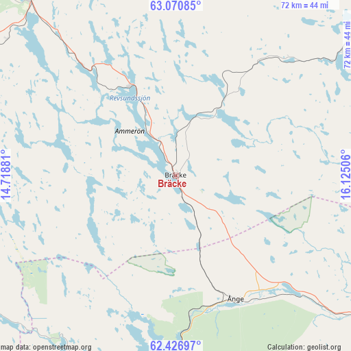
Bräcke GPS coordinates[2]
62° 45' 2.412" North, 15° 25' 18.948" East
| Map corner | latitude | longitude |
|---|---|---|
| Upper-left | 63.07085°, | 14.71881° |
| Center: | 62.75067°, | 15.42193° |
| Lower-right: | 62.42697°, | 16.12506° |
| Map W x H: | 71.6×71.6 km | = 44.5×44.5mi |
| max Lat: | 67.85572° ⇑11.8% North |
| Bräcke: | 62.75067° |
| min Lat: | ⇓88.2% South 55.34337° |
| min Long | Bräcke | max Long |
| 11.1712° | 15.42193° | 24.13676° |
| W 54.7%⇐ | ⇒45.3% E |
Elevation
Elevation of Bräcke is 307 m = 1007 ft, and this is 224.4 m = 736 ft above average elevation for this country.
| Max E: |
663 m = 2175 ft | 3.3% |
| Bräcke | 307 m 1007 ft | |
| Avg. | 82.6 m = 271 ft | |
Min E: |
-1 m = -3 ft | 96.7% |
See also: Sweden elevation on elevation.city.
Geographical zone
Bräcke is located in North temperate zone (between Tropic of Cancer and the Arctic Circle). Distance of this North polar circle is 424 km =263.5 mi to North.| Distance of | km | miles | from Bräcke |
|---|---|---|---|
| North Pole | 3029.8 | 1882.6 | to North |
| Arctic Circle | 424 | 263.5 | to North |
| Tropic Cancer | 4371.3 | 2716.2 | to South |
| Equator | 6977.2 | 4335.4 | to South |


Nearby cities:
15 places around Bräcke: (largest is in red/bold)
• Brunflo
46.9 km =29.1 mi,  320°
320°
• Fränsta
47.4 km =29.5 mi,  126°
126°
• Gällö
20.4 km =12.7 mi,  331°
331°
• Hackås
49.5 km =30.8 mi,  291°
291°
• Hammarstrand
61.8 km =38.4 mi,  49°
49°
• Hoverberg
50.1 km =31.1 mi,  278°
278°
• Hållsta
36.1 km =22.4 mi, 320°
• Lit
69.7 km =43.3 mi,  335°
335°
• Ljungaverk
43 km =26.7 mi, 132°
• Stugun
47.1 km =29.3 mi,  11°
11°
• Stöde
70.1 km =43.6 mi,  121°
121°
• Svenstavik
50.2 km =31.2 mi,  272°
272°
• Ytterhogdal
68.6 km =42.6 mi,  201°
201°
• Ånge
27.9 km =17.3 mi,  154°
154°
• Östersund
62 km =38.5 mi, 320°
Sources, notices
• [Note1] Compared only with cities in Sweden existing in our database
• [Src1] Map data: © OpenStreetMap contributors (CC-BY-SA)
• [Src2] Other city data from geonames.org with taken over terms of usage.
• [Src3] Geographical zone / Annual Mean Temperature by Robert A. Rohde @ Wikipedia
