Fjugesta geodata
Fjugesta (Örebro) is a seat of a second-order administrative division; located in Sweden in Europe/Stockholm (GMT+2) time zone. With population of 2,160 people, there are 499 cities with bigger population in this country. Compared to other cities in Sweden, 56.5% of cities are located further ↓South; 52.7% of cities are located further →East and 59.7% of cities have lower elevation than Fjugesta. Note1


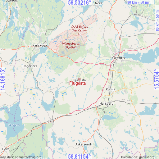
Fjugesta GPS coordinates[2]
59° 10' 25.5" North, 14° 52' 20.172" East
| Map corner | latitude | longitude |
|---|---|---|
| Upper-left | 59.53216°, | 14.16915° |
| Center: | 59.17375°, | 14.87227° |
| Lower-right: | 58.81154°, | 15.5754° |
| Map W x H: | 80.1×80.1 km | = 49.8×49.8mi |
| max Lat: | 67.85572° ⇑43.5% North |
| Fjugesta: | 59.17375° |
| min Lat: | ⇓56.5% South 55.34337° |
| min Long | Fjugesta | max Long |
| 11.1712° | 14.87227° | 24.13676° |
| W 47.3%⇐ | ⇒52.7% E |
Elevation
Elevation of Fjugesta is 69 m = 226 ft, and this is 13.6 m = 45 ft below average elevation for this country.
| Max E: |
663 m = 2175 ft | 40.3% |
| Avg. | 82.6 m = 271 ft | |
| Fjugesta | 69 m = 226 ft | |
Min E: |
-1 m = -3 ft | 59.7% |
See also: Sweden elevation on elevation.city.
Geographical zone
Fjugesta is located in North temperate zone (between Tropic of Cancer and the Arctic Circle). Distance of this North polar circle is 821.7 km =510.6 mi to North.| Distance of | km | miles | from Fjugesta |
|---|---|---|---|
| North Pole | 3427.6 | 2129.8 | to North |
| Arctic Circle | 821.7 | 510.6 | to North |
| Tropic Cancer | 3973.6 | 2469.1 | to South |
| Equator | 6579.5 | 4088.3 | to South |


Nearby cities:
15 places around Fjugesta: (largest is in red/bold)
• Baggetorp
13.9 km =8.6 mi,  259°
259°
• Garphyttan
15.1 km =9.4 mi,  16°
16°
• Hallsberg
18.2 km =11.3 mi,  131°
131°
• Hällabrottet
19.7 km =12.2 mi,  108°
108°
• Kumla
16.3 km =10.1 mi, 108°
• Latorpsbruk
12.7 km =7.9 mi,  29°
29°
• Mosås
15.2 km =9.4 mi,  78°
78°
• Mullhyttan
11.1 km =6.9 mi, 256°
• Norra Bro
22 km =13.7 mi, 77°
• Velanda
11.5 km =7.1 mi, 75°
• Vintrosa
9.6 km =6 mi, 27°
• Vretstorp
15.6 km =9.7 mi,  181°
181°
• Åbytorp
12.7 km =7.9 mi,  115°
115°
• Åsbro
21.8 km =13.5 mi,  152°
152°
• Östansjö
15.1 km =9.4 mi,  155°
155°
Sources, notices
• [Note1] Compared only with cities in Sweden existing in our database
• [Src1] Map data: © OpenStreetMap contributors (CC-BY-SA)
• [Src2] Other city data from geonames.org with taken over terms of usage.
• [Src3] Geographical zone / Annual Mean Temperature by Robert A. Rohde @ Wikipedia
