Falkenberg geodata
Falkenberg (Halland) is a seat of a second-order administrative division; located in Sweden in Europe/Stockholm (GMT+2) time zone. With population of 24,099 people, there are 63 cities with bigger population in this country. Compared to other cities in Sweden, 78.8% of cities are located further ↑North; 88.5% of cities are located further →East and 80.9% of cities have higher elevation than Falkenberg. Note1


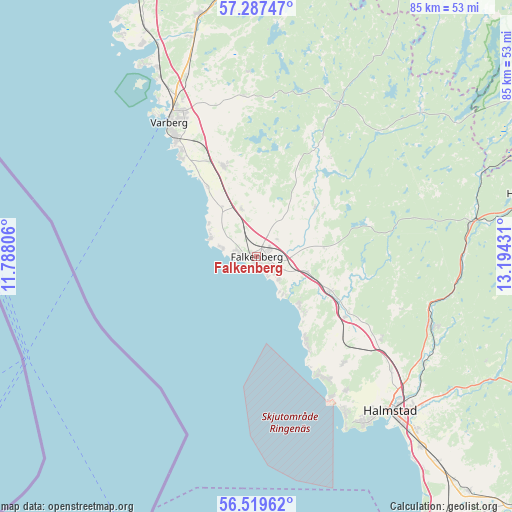
Falkenberg GPS coordinates[2]
56° 54' 19.872" North, 12° 29' 28.248" East
| Map corner | latitude | longitude |
|---|---|---|
| Upper-left | 57.28747°, | 11.78806° |
| Center: | 56.90552°, | 12.49118° |
| Lower-right: | 56.51962°, | 13.19431° |
| Map W x H: | 85.4×85.4 km | = 53.1×53.1mi |
| max Lat: | 67.85572° ⇑78.8% North |
| Falkenberg: | 56.90552° |
| min Lat: | ⇓21.2% South 55.34337° |
| min Long | Falkenberg | max Long |
| 11.1712° | 12.49118° | 24.13676° |
| W 11.5%⇐ | ⇒88.5% E |
Elevation
Elevation of Falkenberg is 15 m = 49 ft, and this is 67.6 m = 222 ft below average elevation for this country.
| Max E: |
663 m = 2175 ft | 80.9% |
| Avg. | 82.6 m = 271 ft | |
| Falkenberg | 15 m = 49 ft | |
Min E: |
-1 m = -3 ft | 19.1% |
See also: Sweden elevation on elevation.city.
Geographical zone
Falkenberg is located in North temperate zone (between Tropic of Cancer and the Arctic Circle). Distance of this North polar circle is 1073.9 km =667.3 mi to North.| Distance of | km | miles | from Falkenberg |
|---|---|---|---|
| North Pole | 3679.8 | 2286.5 | to North |
| Arctic Circle | 1073.9 | 667.3 | to North |
| Tropic Cancer | 3721.4 | 2312.4 | to South |
| Equator | 6327.3 | 3931.6 | to South |


Nearby cities:
15 places around Falkenberg: (largest is in red/bold)
• Getinge
17.7 km =11 mi,  123°
123°
• Glommen
9.1 km =5.7 mi,  289°
289°
• Harplinge
22.9 km =14.2 mi,  141°
141°
• Haverdal
23.2 km =14.4 mi,  151°
151°
• Kvibille
24.8 km =15.4 mi, 123°
• Långås
9 km =5.6 mi,  343°
343°
• Skrea
5.2 km =3.2 mi, 118°
• Slöinge
13.2 km =8.2 mi, 117°
• Steninge
17.4 km =10.8 mi, 150°
• Träslövsläge
20.9 km =13 mi,  322°
322°
• Tvååker
16.1 km =10 mi, 339°
• Varberg
26.6 km =16.5 mi,  326°
326°
• Vessigebro
12.9 km =8 mi,  48°
48°
• Villshärad
26.6 km =16.5 mi, 152°
• Vinberg
5.9 km =3.7 mi,  33°
33°
Sources, notices
• [Note1] Compared only with cities in Sweden existing in our database
• [Src1] Map data: © OpenStreetMap contributors (CC-BY-SA)
• [Src2] Other city data from geonames.org with taken over terms of usage.
• [Src3] Geographical zone / Annual Mean Temperature by Robert A. Rohde @ Wikipedia
