Långås geodata
Långås (Halland) is a populated place; located in Sweden in Europe/Stockholm (GMT+2) time zone. With population of 539 people, there are 1253 cities with bigger population in this country. Compared to other cities in Sweden, 78.1% of cities are located further ↑North; 89% of cities are located further →East and 75.3% of cities have higher elevation than Långås. Note1


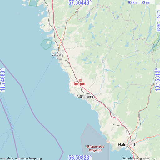
Långås GPS coordinates[2]
56° 58' 59.988" North, 12° 27' 0" East
| Map corner | latitude | longitude |
|---|---|---|
| Upper-left | 57.36448°, | 11.74688° |
| Center: | 56.98333°, | 12.45° |
| Lower-right: | 56.59823°, | 13.15313° |
| Map W x H: | 85.2×85.2 km | = 52.9×52.9mi |
| max Lat: | 67.85572° ⇑78.1% North |
| Långås: | 56.98333° |
| min Lat: | ⇓21.9% South 55.34337° |
| min Long | Långås | max Long |
| 11.1712° | 12.45° | 24.13676° |
| W 11%⇐ | ⇒89% E |
Elevation
Elevation of Långås is 20 m = 66 ft, and this is 62.6 m = 205 ft below average elevation for this country.
| Max E: |
663 m = 2175 ft | 75.3% |
| Avg. | 82.6 m = 271 ft | |
| Långås | 20 m = 66 ft | |
Min E: |
-1 m = -3 ft | 24.7% |
See also: Sweden elevation on elevation.city.
Geographical zone
Långås is located in North temperate zone (between Tropic of Cancer and the Arctic Circle). Distance of this North polar circle is 1065.2 km =661.9 mi to North.| Distance of | km | miles | from Långås |
|---|---|---|---|
| North Pole | 3671.1 | 2281.1 | to North |
| Arctic Circle | 1065.2 | 661.9 | to North |
| Tropic Cancer | 3730 | 2317.7 | to South |
| Equator | 6336 | 3937 | to South |


Nearby cities:
15 places around Långås: (largest is in red/bold)
• Falkenberg
9 km =5.6 mi,  163°
163°
• Glommen
8.2 km =5.1 mi,  227°
227°
• Rolfstorp
18.5 km =11.5 mi,  0°
0°
• Skrea
13.2 km =8.2 mi,  147°
147°
• Skällinge
22.3 km =13.9 mi, 2°
• Slöinge
20.5 km =12.7 mi,  136°
136°
• Träslövsläge
13 km =8.1 mi,  307°
307°
• Trönninge
20.3 km =12.6 mi,  332°
332°
• Trönningenäs
21.9 km =13.6 mi,  321°
321°
• Tvååker
7.2 km =4.5 mi, 334°
• Tångaberg
25.1 km =15.6 mi, 327°
• Ullared
23.2 km =14.4 mi,  44°
44°
• Varberg
18.2 km =11.3 mi, 318°
• Vessigebro
12.1 km =7.5 mi,  90°
90°
• Vinberg
6.8 km =4.2 mi,  123°
123°
Sources, notices
• [Note1] Compared only with cities in Sweden existing in our database
• [Src1] Map data: © OpenStreetMap contributors (CC-BY-SA)
• [Src2] Other city data from geonames.org with taken over terms of usage.
• [Src3] Geographical zone / Annual Mean Temperature by Robert A. Rohde @ Wikipedia
