Djurås geodata
Djurås (Dalarna) is a populated place; located in Sweden in Europe/Stockholm (GMT+2) time zone. With population of 2,128 people, there are 504 cities with bigger population in this country. Compared to other cities in Sweden, 79.2% of cities are located further ↓South; 51.4% of cities are located further ←West and 85.8% of cities have lower elevation than Djurås. Note1
Administrative division(s):
- Level 1: Dalarna
- Level 2: Gagnefs Kommun
- Level 3: Gagnef
- Level 4: Gagnef socken


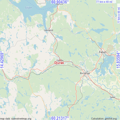
Djurås GPS coordinates[2]
60° 33' 38.196" North, 15° 7' 58.116" East
| Map corner | latitude | longitude |
|---|---|---|
| Upper-left | 60.90436°, | 14.42969° |
| Center: | 60.56061°, | 15.13281° |
| Lower-right: | 60.21317°, | 15.83594° |
| Map W x H: | 76.9×76.9 km | = 47.8×47.8mi |
| max Lat: | 67.85572° ⇑20.8% North |
| Djurås: | 60.56061° |
| min Lat: | ⇓79.2% South 55.34337° |
| min Long | Djurås | max Long |
| 11.1712° | 15.13281° | 24.13676° |
| W 51.4%⇐ | ⇒48.6% E |
Elevation
Elevation of Djurås is 172 m = 564 ft, and this is 89.4 m = 293 ft above average elevation for this country.
| Max E: |
663 m = 2175 ft | 14.2% |
| Djurås | 172 m 564 ft | |
| Avg. | 82.6 m = 271 ft | |
Min E: |
-1 m = -3 ft | 85.8% |
See also: Sweden elevation on elevation.city.
Geographical zone
Djurås is located in North temperate zone (between Tropic of Cancer and the Arctic Circle). Distance of this North polar circle is 667.5 km =414.8 mi to North.| Distance of | km | miles | from Djurås |
|---|---|---|---|
| North Pole | 3273.4 | 2034 | to North |
| Arctic Circle | 667.5 | 414.8 | to North |
| Tropic Cancer | 4127.8 | 2564.9 | to South |
| Equator | 6733.7 | 4184.1 | to South |


Nearby cities:
15 places around Djurås: (largest is in red/bold)
• Björbo
25.4 km =15.8 mi,  243°
243°
• Borlänge
18.6 km =11.6 mi,  116°
116°
• Bäsna
4.8 km =3 mi,  129°
129°
• Djurmo
3 km =1.9 mi,  112°
112°
• Floda
19.6 km =12.2 mi,  251°
251°
• Gagnef
5.2 km =3.2 mi,  324°
324°
• Grycksbo
23.8 km =14.8 mi,  53°
53°
• Häradsbygden
16.4 km =10.2 mi,  340°
340°
• Insjön
13.1 km =8.1 mi,  350°
350°
• Leksand
20.2 km =12.6 mi, 339°
• Mockfjärd
11.3 km =7 mi,  233°
233°
• Ornäs
23.1 km =14.4 mi,  104°
104°
• Romme
24.6 km =15.3 mi, 125°
• Smedby
16.1 km =10 mi, 343°
• Sågmyra
19.2 km =11.9 mi,  25°
25°
Sources, notices
• [Note1] Compared only with cities in Sweden existing in our database
• [Src1] Map data: © OpenStreetMap contributors (CC-BY-SA)
• [Src2] Other city data from geonames.org with taken over terms of usage.
• [Src3] Geographical zone / Annual Mean Temperature by Robert A. Rohde @ Wikipedia
