Borlänge geodata
Borlänge (Dalarna) is a seat of a second-order administrative division; located in Sweden in Europe/Stockholm (GMT+2) time zone. With population of 41,955 people, there are 34 cities with bigger population in this country. Compared to other cities in Sweden, 78.2% of cities are located further ↓South; 54.9% of cities are located further ←West and 75.9% of cities have lower elevation than Borlänge. Note1


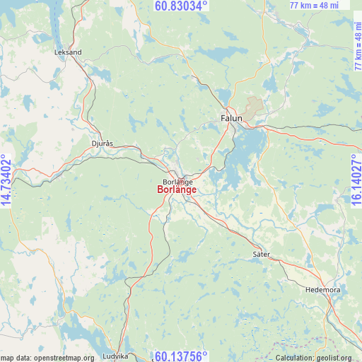
Borlänge GPS coordinates[2]
60° 29' 8.88" North, 15° 26' 13.704" East
| Map corner | latitude | longitude |
|---|---|---|
| Upper-left | 60.83034°, | 14.73402° |
| Center: | 60.4858°, | 15.43714° |
| Lower-right: | 60.13756°, | 16.14027° |
| Map W x H: | 77×77 km | = 47.8×47.8mi |
| max Lat: | 67.85572° ⇑21.8% North |
| Borlänge: | 60.4858° |
| min Lat: | ⇓78.2% South 55.34337° |
| min Long | Borlänge | max Long |
| 11.1712° | 15.43714° | 24.13676° |
| W 54.9%⇐ | ⇒45.1% E |
Elevation
Elevation of Borlänge is 124 m = 407 ft, and this is 41.4 m = 136 ft above average elevation for this country.
| Max E: |
663 m = 2175 ft | 24.1% |
| Borlänge | 124 m 407 ft | |
| Avg. | 82.6 m = 271 ft | |
Min E: |
-1 m = -3 ft | 75.9% |
See also: Borlänge elevation on elevation.city.
Geographical zone
Borlänge is located in North temperate zone (between Tropic of Cancer and the Arctic Circle). Distance of this North polar circle is 675.8 km =419.9 mi to North.| Distance of | km | miles | from Borlänge |
|---|---|---|---|
| North Pole | 3281.7 | 2039.2 | to North |
| Arctic Circle | 675.8 | 419.9 | to North |
| Tropic Cancer | 4119.5 | 2559.7 | to South |
| Equator | 6725.4 | 4179 | to South |


Nearby cities:
15 places around Borlänge: (largest is in red/bold)
• Bäsna
14 km =8.7 mi,  292°
292°
• Djurmo
15.6 km =9.7 mi,  297°
297°
• Djurås
18.6 km =11.6 mi, 296°
• Enbacka
12.1 km =7.5 mi,  134°
134°
• Falun
16.7 km =10.4 mi,  38°
38°
• Gagnef
23.3 km =14.5 mi, 302°
• Grycksbo
22.6 km =14 mi,  6°
6°
• Mora
13.1 km =8.1 mi,  136°
136°
• Ornäs
6.3 km =3.9 mi,  65°
65°
• Romme
6.8 km =4.2 mi,  149°
149°
• Sundborn
25.6 km =15.9 mi, 44°
• Säter
23.1 km =14.4 mi, 131°
• Tomtebo
17.1 km =10.6 mi,  116°
116°
• Torsång
7.4 km =4.6 mi,  106°
106°
• Vika
15.6 km =9.7 mi,  78°
78°
Sources, notices
• [Note1] Compared only with cities in Sweden existing in our database
• [Src1] Map data: © OpenStreetMap contributors (CC-BY-SA)
• [Src2] Other city data from geonames.org with taken over terms of usage.
• [Src3] Geographical zone / Annual Mean Temperature by Robert A. Rohde @ Wikipedia
