Skanör med Falsterbo geodata
Skanör med Falsterbo (Skåne) is a populated place; located in Sweden in Europe/Stockholm (GMT+2) time zone. With population of 7,077 people, there are 207 cities with bigger population in this country. Compared to other cities in Sweden, 99.5% of cities are located further ↑North; 83.5% of cities are located further →East and 96.4% of cities have higher elevation than Skanör med Falsterbo. Note1


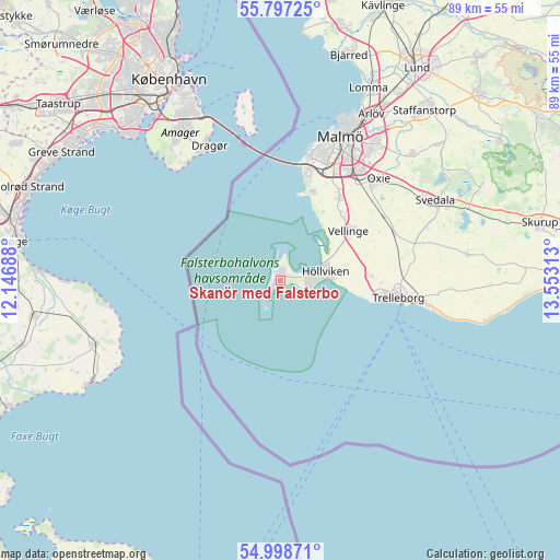
Skanör med Falsterbo GPS coordinates[2]
55° 24' 0" North, 12° 51' 0" East
| Map corner | latitude | longitude |
|---|---|---|
| Upper-left | 55.79725°, | 12.14688° |
| Center: | 55.4°, | 12.85° |
| Lower-right: | 54.99871°, | 13.55313° |
| Map W x H: | 88.8×88.8 km | = 55.2×55.2mi |
| max Lat: | 67.85572° ⇑99.5% North |
| Skanör med Falsterbo: | 55.4° |
| min Lat: | ⇓0.5% South 55.34337° |
| min Long | Skanör med Fal | max Long |
| 11.1712° | 12.85° | 24.13676° |
| W 16.5%⇐ | ⇒83.5% E |
Elevation
Elevation of Skanör med Falsterbo is 4 m = 13 ft, and this is 78.6 m = 258 ft below average elevation for this country.
| Max E: |
663 m = 2175 ft | 96.4% |
| Avg. | 82.6 m = 271 ft | |
| Skanör med Falsterbo | 4 m = 13 ft | |
Min E: |
-1 m = -3 ft | 3.6% |
See also: Sweden elevation on elevation.city.
Geographical zone
Skanör med Falsterbo is located in North temperate zone (between Tropic of Cancer and the Arctic Circle). Distance of this North polar circle is 1241.3 km =771.3 mi to North.| Distance of | km | miles | from Skanör med Falsterbo |
|---|---|---|---|
| North Pole | 3847.2 | 2390.5 | to North |
| Arctic Circle | 1241.3 | 771.3 | to North |
| Tropic Cancer | 3554 | 2208.4 | to South |
| Equator | 6159.9 | 3827.6 | to South |


Nearby cities:
15 places around Skanör med Falsterbo: (largest is in red/bold)
• Bunkeflostrand
16.8 km =10.4 mi,  16°
16°
• Gessie Villastad
13 km =8.1 mi,  31°
31°
• Hököpinge
14.4 km =8.9 mi,  43°
43°
• Höllviken
6.8 km =4.2 mi,  80°
80°
• Kurland
15 km =9.3 mi,  100°
100°
• Ljunghusen
4.7 km =2.9 mi,  92°
92°
• Oxie
22 km =13.7 mi, 44°
• Skegrie
14.3 km =8.9 mi, 87°
• Skåre
12.8 km =8 mi, 98°
• Trelleborg
19.6 km =12.2 mi, 98°
• Tygelsjö
16.1 km =10 mi, 36°
• Vellinge
13.3 km =8.3 mi,  53°
53°
• Vintrie
18.2 km =11.3 mi, 23°
• Västra Ingelstad
19.4 km =12.1 mi,  58°
58°
• Östra Grevie
19.4 km =12.1 mi,  67°
67°
Sources, notices
• [Note1] Compared only with cities in Sweden existing in our database
• [Src1] Map data: © OpenStreetMap contributors (CC-BY-SA)
• [Src2] Other city data from geonames.org with taken over terms of usage.
• [Src3] Geographical zone / Annual Mean Temperature by Robert A. Rohde @ Wikipedia
