Arboga geodata
Arboga (Västmanland) is a seat of a second-order administrative division; located in Sweden in Europe/Stockholm (GMT+2) time zone. With population of 10,841 people, there are 139 cities with bigger population in this country. Compared to other cities in Sweden, 63.5% of cities are located further ↓South; 60% of cities are located further ←West and 76.9% of cities have higher elevation than Arboga. Note1


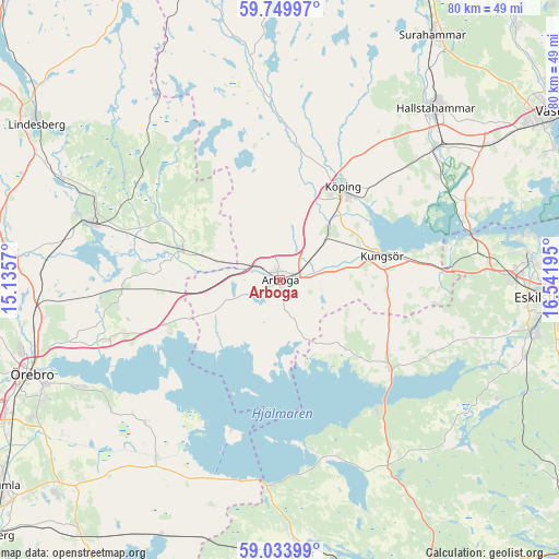
Arboga GPS coordinates[2]
59° 23' 37.932" North, 15° 50' 19.752" East
| Map corner | latitude | longitude |
|---|---|---|
| Upper-left | 59.74997°, | 15.1357° |
| Center: | 59.39387°, | 15.83882° |
| Lower-right: | 59.03399°, | 16.54195° |
| Map W x H: | 79.6×79.6 km | = 49.5×49.5mi |
| max Lat: | 67.85572° ⇑36.5% North |
| Arboga: | 59.39387° |
| min Lat: | ⇓63.5% South 55.34337° |
| min Long | Arboga | max Long |
| 11.1712° | 15.83882° | 24.13676° |
| W 60%⇐ | ⇒40% E |
Elevation
Elevation of Arboga is 18 m = 59 ft, and this is 64.6 m = 212 ft below average elevation for this country.
| Max E: |
663 m = 2175 ft | 76.9% |
| Avg. | 82.6 m = 271 ft | |
| Arboga | 18 m = 59 ft | |
Min E: |
-1 m = -3 ft | 23.1% |
See also: Sweden elevation on elevation.city.
Geographical zone
Arboga is located in North temperate zone (between Tropic of Cancer and the Arctic Circle). Distance of this North polar circle is 797.2 km =495.4 mi to North.| Distance of | km | miles | from Arboga |
|---|---|---|---|
| North Pole | 3403.1 | 2114.6 | to North |
| Arctic Circle | 797.2 | 495.4 | to North |
| Tropic Cancer | 3998.1 | 2484.3 | to South |
| Equator | 6604 | 4103.5 | to South |


Nearby cities:
15 places around Arboga: (largest is in red/bold)
• Fellingsbro
15.1 km =9.4 mi,  286°
286°
• Frövi
27.9 km =17.3 mi, 286°
• Glanshammar
26.3 km =16.3 mi,  250°
250°
• Horn
27.8 km =17.3 mi,  64°
64°
• Kolsva
22.9 km =14.2 mi,  359°
359°
• Kungsör
14.9 km =9.3 mi,  77°
77°
• Kvicksund
28 km =17.4 mi, 76°
• Köping
15.9 km =9.9 mi,  33°
33°
• Mellösa
28.9 km =18 mi,  221°
221°
• Rinkaby
16.6 km =10.3 mi,  299°
299°
• Skillinge
16.1 km =10 mi, 77°
• Stora Mellösa
27.5 km =17.1 mi, 224°
• Strömsholm
27.2 km =16.9 mi, 57°
• Sylta
17.5 km =10.9 mi, 27°
• Valskog
8 km =5 mi,  48°
48°
Sources, notices
• [Note1] Compared only with cities in Sweden existing in our database
• [Src1] Map data: © OpenStreetMap contributors (CC-BY-SA)
• [Src2] Other city data from geonames.org with taken over terms of usage.
• [Src3] Geographical zone / Annual Mean Temperature by Robert A. Rohde @ Wikipedia
