Rinkaby geodata
Rinkaby (Örebro) is a populated place; located in Sweden in Europe/Stockholm (GMT+2) time zone. With population of 700 people, there are 1064 cities with bigger population in this country. Compared to other cities in Sweden, 65.6% of cities are located further ↓South; 56.6% of cities are located further ←West and 58.8% of cities have higher elevation than Rinkaby. Note1


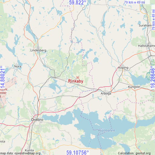
Rinkaby GPS coordinates[2]
59° 28' 0.012" North, 15° 34' 59.988" East
| Map corner | latitude | longitude |
|---|---|---|
| Upper-left | 59.822°, | 14.88021° |
| Center: | 59.46667°, | 15.58333° |
| Lower-right: | 59.10756°, | 16.28646° |
| Map W x H: | 79.4×79.4 km | = 49.3×49.3mi |
| max Lat: | 67.85572° ⇑34.4% North |
| Rinkaby: | 59.46667° |
| min Lat: | ⇓65.6% South 55.34337° |
| min Long | Rinkaby | max Long |
| 11.1712° | 15.58333° | 24.13676° |
| W 56.6%⇐ | ⇒43.4% E |
Elevation
Elevation of Rinkaby is 37 m = 121 ft, and this is 45.6 m = 150 ft below average elevation for this country.
| Max E: |
663 m = 2175 ft | 58.8% |
| Avg. | 82.6 m = 271 ft | |
| Rinkaby | 37 m = 121 ft | |
Min E: |
-1 m = -3 ft | 41.2% |
See also: Sweden elevation on elevation.city.
Geographical zone
Rinkaby is located in North temperate zone (between Tropic of Cancer and the Arctic Circle). Distance of this North polar circle is 789.1 km =490.3 mi to North.| Distance of | km | miles | from Rinkaby |
|---|---|---|---|
| North Pole | 3395 | 2109.6 | to North |
| Arctic Circle | 789.1 | 490.3 | to North |
| Tropic Cancer | 4006.2 | 2489.3 | to South |
| Equator | 6612.1 | 4108.6 | to South |


Nearby cities:
15 places around Rinkaby: (largest is in red/bold)
• Arboga
16.6 km =10.3 mi,  119°
119°
• Ekeby-Almby
27.1 km =16.8 mi,  211°
211°
• Fellingsbro
3.7 km =2.3 mi,  180°
180°
• Frövi
12.2 km =7.6 mi,  270°
270°
• Glanshammar
19.6 km =12.2 mi, 211°
• Hovsta
24.5 km =15.2 mi,  237°
237°
• Kolsva
20.5 km =12.7 mi,  43°
43°
• Kungsör
29.4 km =18.3 mi,  99°
99°
• Köping
23.7 km =14.7 mi,  77°
77°
• Lindesberg
24.3 km =15.1 mi,  305°
305°
• Stora Mellösa
28.2 km =17.5 mi,  189°
189°
• Sylta
23.8 km =14.8 mi,  71°
71°
• Valskog
20.6 km =12.8 mi, 97°
• Vedevåg
17.7 km =11 mi,  292°
292°
• Ölmbrotorp
21 km =13 mi,  246°
246°
Sources, notices
• [Note1] Compared only with cities in Sweden existing in our database
• [Src1] Map data: © OpenStreetMap contributors (CC-BY-SA)
• [Src2] Other city data from geonames.org with taken over terms of usage.
• [Src3] Geographical zone / Annual Mean Temperature by Robert A. Rohde @ Wikipedia
