Kolsva geodata
Kolsva (Västmanland) is a populated place; located in Sweden in Europe/Stockholm (GMT+2) time zone. With population of 2,440 people, there are 461 cities with bigger population in this country. Compared to other cities in Sweden, 68.1% of cities are located further ↓South; 59.7% of cities are located further ←West and 51.8% of cities have higher elevation than Kolsva. Note1


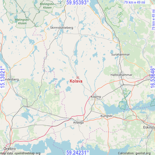
Kolsva GPS coordinates[2]
59° 36' 0" North, 15° 49' 59.988" East
| Map corner | latitude | longitude |
|---|---|---|
| Upper-left | 59.95393°, | 15.13021° |
| Center: | 59.6°, | 15.83333° |
| Lower-right: | 59.24231°, | 16.53646° |
| Map W x H: | 79.1×79.1 km | = 49.2×49.2mi |
| max Lat: | 67.85572° ⇑31.9% North |
| Kolsva: | 59.6° |
| min Lat: | ⇓68.1% South 55.34337° |
| min Long | Kolsva | max Long |
| 11.1712° | 15.83333° | 24.13676° |
| W 59.7%⇐ | ⇒40.3% E |
Elevation
Elevation of Kolsva is 47 m = 154 ft, and this is 35.6 m = 117 ft below average elevation for this country.
| Max E: |
663 m = 2175 ft | 51.8% |
| Avg. | 82.6 m = 271 ft | |
| Kolsva | 47 m = 154 ft | |
Min E: |
-1 m = -3 ft | 48.2% |
See also: Sweden elevation on elevation.city.
Geographical zone
Kolsva is located in North temperate zone (between Tropic of Cancer and the Arctic Circle). Distance of this North polar circle is 774.3 km =481.1 mi to North.| Distance of | km | miles | from Kolsva |
|---|---|---|---|
| North Pole | 3380.2 | 2100.4 | to North |
| Arctic Circle | 774.3 | 481.1 | to North |
| Tropic Cancer | 4021 | 2498.5 | to South |
| Equator | 6626.9 | 4117.8 | to South |


Nearby cities:
15 places around Kolsva: (largest is in red/bold)
• Arboga
22.9 km =14.2 mi,  179°
179°
• Fellingsbro
23.3 km =14.5 mi,  217°
217°
• Hallstahammar
22.3 km =13.9 mi,  86°
86°
• Horn
27.7 km =17.2 mi,  113°
113°
• Kolbäck
22.7 km =14.1 mi,  99°
99°
• Kungsör
24.7 km =15.3 mi,  143°
143°
• Köping
13.1 km =8.1 mi, 136°
• Ramnäs
27.7 km =17.2 mi,  47°
47°
• Rinkaby
20.5 km =12.7 mi, 223°
• Skillinge
25.3 km =15.7 mi, 140°
• Skinnskatteberg
26.8 km =16.7 mi,  342°
342°
• Strömsholm
24.5 km =15.2 mi, 109°
• Surahammar
24.9 km =15.5 mi,  61°
61°
• Sylta
11.2 km =7 mi,  131°
131°
• Valskog
18.7 km =11.6 mi,  160°
160°
Sources, notices
• [Note1] Compared only with cities in Sweden existing in our database
• [Src1] Map data: © OpenStreetMap contributors (CC-BY-SA)
• [Src2] Other city data from geonames.org with taken over terms of usage.
• [Src3] Geographical zone / Annual Mean Temperature by Robert A. Rohde @ Wikipedia
