Trelleborg geodata
Trelleborg (Skåne) is a seat of a second-order administrative division; located in Sweden in Europe/Stockholm (GMT+2) time zone. With population of 29,316 people, there are 53 cities with bigger population in this country. Compared to other cities in Sweden, 99.8% of cities are located further ↑North; 76% of cities are located further →East and 91.5% of cities have higher elevation than Trelleborg. Note1


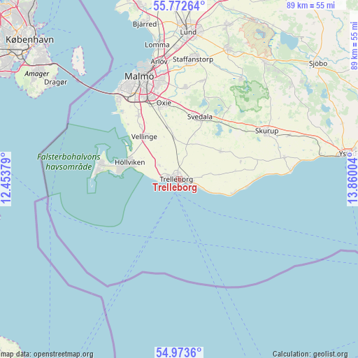
Trelleborg GPS coordinates[2]
55° 22' 30.504" North, 13° 9' 24.876" East
| Map corner | latitude | longitude |
|---|---|---|
| Upper-left | 55.77264°, | 12.45379° |
| Center: | 55.37514°, | 13.15691° |
| Lower-right: | 54.9736°, | 13.86004° |
| Map W x H: | 88.8×88.8 km | = 55.2×55.2mi |
| max Lat: | 67.85572° ⇑99.8% North |
| Trelleborg: | 55.37514° |
| min Lat: | ⇓0.2% South 55.34337° |
| min Long | Trelleborg | max Long |
| 11.1712° | 13.15691° | 24.13676° |
| W 24%⇐ | ⇒76% E |
Elevation
Elevation of Trelleborg is 8 m = 26 ft, and this is 74.6 m = 245 ft below average elevation for this country.
| Max E: |
663 m = 2175 ft | 91.5% |
| Avg. | 82.6 m = 271 ft | |
| Trelleborg | 8 m = 26 ft | |
Min E: |
-1 m = -3 ft | 8.5% |
See also: Sweden elevation on elevation.city.
Geographical zone
Trelleborg is located in North temperate zone (between Tropic of Cancer and the Arctic Circle). Distance of this North polar circle is 1244 km =773 mi to North.| Distance of | km | miles | from Trelleborg |
|---|---|---|---|
| North Pole | 3849.9 | 2392.2 | to North |
| Arctic Circle | 1244 | 773 | to North |
| Tropic Cancer | 3551.2 | 2206.6 | to South |
| Equator | 6157.1 | 3825.8 | to South |


Nearby cities:
15 places around Trelleborg: (largest is in red/bold)
• Anderslöv
12.4 km =7.7 mi,  55°
55°
• Gessie Villastad
18.7 km =11.6 mi,  317°
317°
• Hököpinge
16.2 km =10.1 mi, 324°
• Höllviken
13.3 km =8.3 mi,  286°
286°
• Klagstorp
13.9 km =8.6 mi,  81°
81°
• Kurland
4.6 km =2.9 mi,  269°
269°
• Ljunghusen
14.9 km =9.3 mi,  279°
279°
• Skegrie
6.1 km =3.8 mi,  304°
304°
• Skåre
6.8 km =4.2 mi, 277°
• Smygehamn
13.9 km =8.6 mi,  104°
104°
• Svedala
15.6 km =9.7 mi,  18°
18°
• Tygelsjö
18.6 km =11.6 mi,  327°
327°
• Vellinge
13.8 km =8.6 mi, 320°
• Västra Ingelstad
13.2 km =8.2 mi,  347°
347°
• Östra Grevie
10.3 km =6.4 mi, 351°
Sources, notices
• [Note1] Compared only with cities in Sweden existing in our database
• [Src1] Map data: © OpenStreetMap contributors (CC-BY-SA)
• [Src2] Other city data from geonames.org with taken over terms of usage.
• [Src3] Geographical zone / Annual Mean Temperature by Robert A. Rohde @ Wikipedia
