Upplands Väsby geodata
Upplands Väsby (Stockholm) is a seat of a second-order administrative division; located in Sweden in Europe/Stockholm (GMT+2) time zone. With population of 36,534 people, there are 40 cities with bigger population in this country. Compared to other cities in Sweden, 66.7% of cities are located further ↓South; 84.8% of cities are located further ←West and 78.5% of cities have higher elevation than Upplands Väsby. Note1


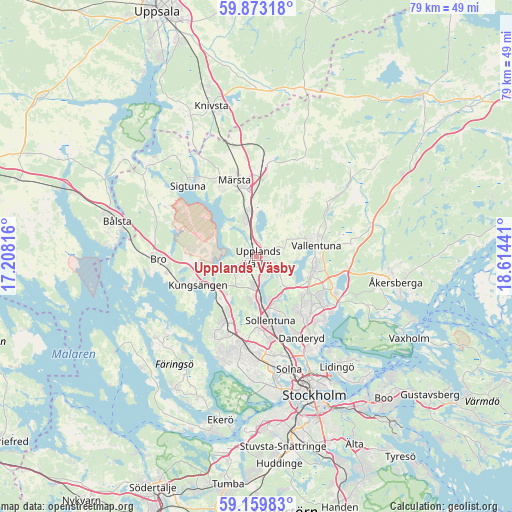
Upplands Väsby GPS coordinates[2]
59° 31' 6.204" North, 17° 54' 40.608" East
| Map corner | latitude | longitude |
|---|---|---|
| Upper-left | 59.87318°, | 17.20816° |
| Center: | 59.51839°, | 17.91128° |
| Lower-right: | 59.15983°, | 18.61441° |
| Map W x H: | 79.3×79.3 km | = 49.3×49.3mi |
| max Lat: | 67.85572° ⇑33.3% North |
| Upplands Väsby: | 59.51839° |
| min Lat: | ⇓66.7% South 55.34337° |
| min Long | Upplands Väsby | max Long |
| 11.1712° | 17.91128° | 24.13676° |
| W 84.8%⇐ | ⇒15.2% E |
Elevation
Elevation of Upplands Väsby is 17 m = 56 ft, and this is 65.6 m = 215 ft below average elevation for this country.
| Max E: |
663 m = 2175 ft | 78.5% |
| Avg. | 82.6 m = 271 ft | |
| Upplands Väsby | 17 m = 56 ft | |
Min E: |
-1 m = -3 ft | 21.5% |
See also: Sweden elevation on elevation.city.
Geographical zone
Upplands Väsby is located in North temperate zone (between Tropic of Cancer and the Arctic Circle). Distance of this North polar circle is 783.3 km =486.7 mi to North.| Distance of | km | miles | from Upplands Väsby |
|---|---|---|---|
| North Pole | 3389.2 | 2106 | to North |
| Arctic Circle | 783.3 | 486.7 | to North |
| Tropic Cancer | 4011.9 | 2492.9 | to South |
| Equator | 6617.8 | 4112.1 | to South |


Nearby cities:
15 places around Upplands Väsby: (largest is in red/bold)
• Akalla
11.5 km =7.1 mi,  179°
179°
• Brunna
9.1 km =5.7 mi,  268°
268°
• Enebyberg
12.3 km =7.6 mi,  140°
140°
• Jakobsberg
11.5 km =7.1 mi,  202°
202°
• Kista
13 km =8.1 mi,  171°
171°
• Kungsängen
10.2 km =6.3 mi,  244°
244°
• Lindholmen
12.9 km =8 mi,  55°
55°
• Märsta
11.9 km =7.4 mi,  344°
344°
• Rosersberg
7.4 km =4.6 mi,  347°
347°
• Sollentuna
10.3 km =6.4 mi, 167°
• Steninge
11.1 km =6.9 mi,  327°
327°
• Sylta
11.8 km =7.3 mi,  248°
248°
• Tensta
13.9 km =8.6 mi, 182°
• Täby
12.2 km =7.6 mi,  132°
132°
• Vallentuna
9.5 km =5.9 mi,  79°
79°
Sources, notices
• [Note1] Compared only with cities in Sweden existing in our database
• [Src1] Map data: © OpenStreetMap contributors (CC-BY-SA)
• [Src2] Other city data from geonames.org with taken over terms of usage.
• [Src3] Geographical zone / Annual Mean Temperature by Robert A. Rohde @ Wikipedia
