Luleå geodata
Luleå (Norrbotten) is a seat of a first-order administrative division; located in Sweden in Europe/Stockholm (GMT+2) time zone. With population of 43,574 people, there are 32 cities with bigger population in this country. Compared to other cities in Sweden, 97.3% of cities are located further ↓South; 98.8% of cities are located further ←West and 78.5% of cities have higher elevation than Luleå. Note1


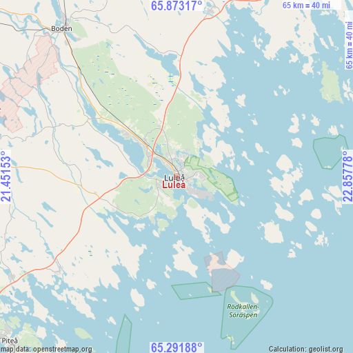
Luleå GPS coordinates[2]
65° 35' 2.94" North, 22° 9' 16.74" East
| Map corner | latitude | longitude |
|---|---|---|
| Upper-left | 65.87317°, | 21.45153° |
| Center: | 65.58415°, | 22.15465° |
| Lower-right: | 65.29188°, | 22.85778° |
| Map W x H: | 64.6×64.6 km | = 40.1×40.1mi |
| max Lat: | 67.85572° ⇑2.7% North |
| Luleå: | 65.58415° |
| min Lat: | ⇓97.3% South 55.34337° |
| min Long | Luleå | max Long |
| 11.1712° | 22.15465° | 24.13676° |
| W 98.8%⇐ | ⇒1.2% E |
Elevation
Elevation of Luleå is 17 m = 56 ft, and this is 65.6 m = 215 ft below average elevation for this country.
| Max E: |
663 m = 2175 ft | 78.5% |
| Avg. | 82.6 m = 271 ft | |
| Luleå | 17 m = 56 ft | |
Min E: |
-1 m = -3 ft | 21.5% |
See also: Luleå elevation on elevation.city.
Geographical zone
Luleå is located in North temperate zone (between Tropic of Cancer and the Arctic Circle). Distance of this North polar circle is 108.9 km =67.7 mi to North.| Distance of | km | miles | from Luleå |
|---|---|---|---|
| North Pole | 2714.8 | 1686.9 | to North |
| Arctic Circle | 108.9 | 67.7 | to North |
| Tropic Cancer | 4686.4 | 2912 | to South |
| Equator | 7292.3 | 4531.2 | to South |


Nearby cities:
15 places around Luleå: (largest is in red/bold)
• Alvik
19.4 km =12.1 mi,  247°
247°
• Antnäs
15 km =9.3 mi,  257°
257°
• Bensbyn
7.6 km =4.7 mi,  32°
32°
• Bergnäset
2.2 km =1.4 mi, 251°
• Björkskatan
3.4 km =2.1 mi,  17°
17°
• Boden
34.2 km =21.3 mi,  321°
321°
• Gammelstad
9 km =5.6 mi,  313°
313°
• Måttsund
12.3 km =7.6 mi, 252°
• Norrfjärden
35.3 km =21.9 mi,  238°
238°
• Rosvik
26.8 km =16.7 mi,  231°
231°
• Rutvik
10.2 km =6.3 mi,  342°
342°
• Råneå
30.7 km =19.1 mi,  11°
11°
• Sävast
28.3 km =17.6 mi, 316°
• Södra Sunderbyn
13 km =8.1 mi, 310°
• Töre
43 km =26.7 mi, 31°
Sources, notices
• [Note1] Compared only with cities in Sweden existing in our database
• [Src1] Map data: © OpenStreetMap contributors (CC-BY-SA)
• [Src2] Other city data from geonames.org with taken over terms of usage.
• [Src3] Geographical zone / Annual Mean Temperature by Robert A. Rohde @ Wikipedia
