Alvik geodata
Alvik (Norrbotten) is a populated place; located in Sweden in Europe/Stockholm (GMT+2) time zone. With population of 771 people, there are 995 cities with bigger population in this country. Compared to other cities in Sweden, 96.9% of cities are located further ↓South; 98.2% of cities are located further ←West and 97.4% of cities have higher elevation than Alvik. Note1


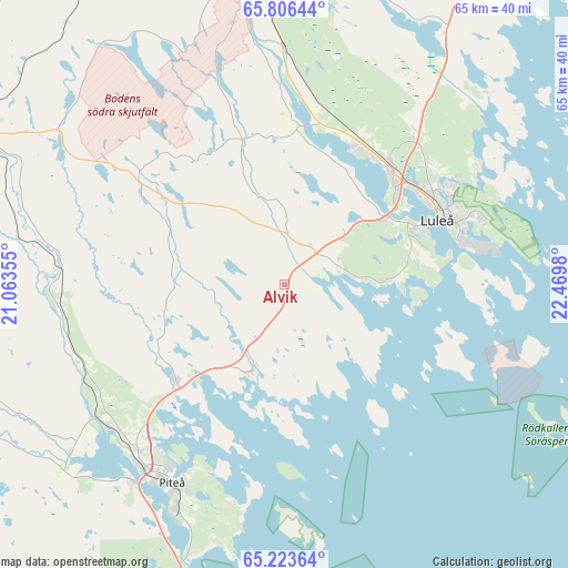
Alvik GPS coordinates[2]
65° 31' 0.012" North, 21° 46' 0.012" East
| Map corner | latitude | longitude |
|---|---|---|
| Upper-left | 65.80644°, | 21.06355° |
| Center: | 65.51667°, | 21.76667° |
| Lower-right: | 65.22364°, | 22.4698° |
| Map W x H: | 64.8×64.8 km | = 40.3×40.3mi |
| max Lat: | 67.85572° ⇑3.1% North |
| Alvik: | 65.51667° |
| min Lat: | ⇓96.9% South 55.34337° |
| min Long | Alvik | max Long |
| 11.1712° | 21.76667° | 24.13676° |
| W 98.2%⇐ | ⇒1.8% E |
Elevation
Elevation of Alvik is 3 m = 10 ft, and this is 79.6 m = 261 ft below average elevation for this country.
| Max E: |
663 m = 2175 ft | 97.4% |
| Avg. | 82.6 m = 271 ft | |
| Alvik | 3 m = 10 ft | |
Min E: |
-1 m = -3 ft | 2.6% |
See also: Sweden elevation on elevation.city.
Geographical zone
Alvik is located in North temperate zone (between Tropic of Cancer and the Arctic Circle). Distance of this North polar circle is 116.4 km =72.3 mi to North.| Distance of | km | miles | from Alvik |
|---|---|---|---|
| North Pole | 2722.3 | 1691.6 | to North |
| Arctic Circle | 116.4 | 72.3 | to North |
| Tropic Cancer | 4678.9 | 2907.3 | to South |
| Equator | 7284.8 | 4526.6 | to South |


Nearby cities:
15 places around Alvik: (largest is in red/bold)
• Antnäs
5.3 km =3.3 mi,  36°
36°
• Bensbyn
25.9 km =16.1 mi,  57°
57°
• Bergnäset
17.1 km =10.6 mi,  66°
66°
• Bergsviken
29.9 km =18.6 mi,  216°
216°
• Björkskatan
21.7 km =13.5 mi, 60°
• Gammelstad
17.7 km =11 mi, 39°
• Hortlax
31 km =19.3 mi,  212°
212°
• Luleå
19.4 km =12.1 mi, 67°
• Måttsund
7.2 km =4.5 mi, 58°
• Norrfjärden
16.4 km =10.2 mi,  228°
228°
• Piteå
25.9 km =16.1 mi, 210°
• Rosvik
9.8 km =6.1 mi,  198°
198°
• Rutvik
22.7 km =14.1 mi, 40°
• Sävast
28.2 km =17.5 mi,  356°
356°
• Södra Sunderbyn
17.8 km =11.1 mi,  26°
26°
Sources, notices
• [Note1] Compared only with cities in Sweden existing in our database
• [Src1] Map data: © OpenStreetMap contributors (CC-BY-SA)
• [Src2] Other city data from geonames.org with taken over terms of usage.
• [Src3] Geographical zone / Annual Mean Temperature by Robert A. Rohde @ Wikipedia
