Antnäs geodata
Antnäs (Norrbotten) is a populated place; located in Sweden in Europe/Stockholm (GMT+2) time zone. With population of 889 people, there are 891 cities with bigger population in this country. Compared to other cities in Sweden, 97.1% of cities are located further ↓South; 98.3% of cities are located further ←West and 96.4% of cities have higher elevation than Antnäs. Note1


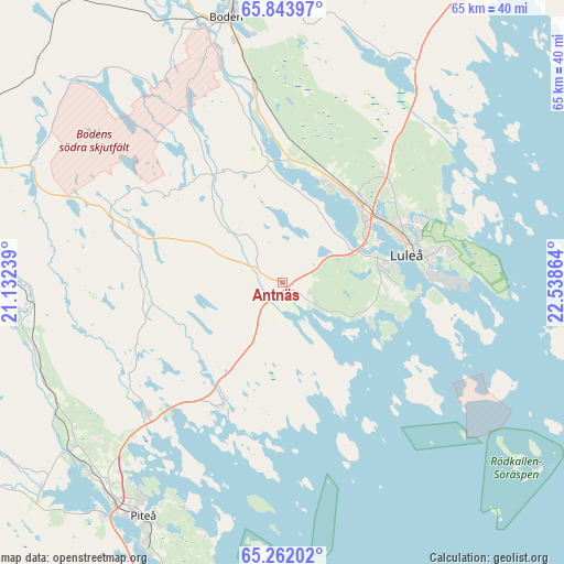
Antnäs GPS coordinates[2]
65° 33' 16.632" North, 21° 50' 7.836" East
| Map corner | latitude | longitude |
|---|---|---|
| Upper-left | 65.84397°, | 21.13239° |
| Center: | 65.55462°, | 21.83551° |
| Lower-right: | 65.26202°, | 22.53864° |
| Map W x H: | 64.7×64.7 km | = 40.2×40.2mi |
| max Lat: | 67.85572° ⇑2.9% North |
| Antnäs: | 65.55462° |
| min Lat: | ⇓97.1% South 55.34337° |
| min Long | Antnäs | max Long |
| 11.1712° | 21.83551° | 24.13676° |
| W 98.3%⇐ | ⇒1.7% E |
Elevation
Elevation of Antnäs is 4 m = 13 ft, and this is 78.6 m = 258 ft below average elevation for this country.
| Max E: |
663 m = 2175 ft | 96.4% |
| Avg. | 82.6 m = 271 ft | |
| Antnäs | 4 m = 13 ft | |
Min E: |
-1 m = -3 ft | 3.6% |
See also: Sweden elevation on elevation.city.
Geographical zone
Antnäs is located in North temperate zone (between Tropic of Cancer and the Arctic Circle). Distance of this North polar circle is 112.2 km =69.7 mi to North.| Distance of | km | miles | from Antnäs |
|---|---|---|---|
| North Pole | 2718.1 | 1688.9 | to North |
| Arctic Circle | 112.2 | 69.7 | to North |
| Tropic Cancer | 4683.1 | 2909.9 | to South |
| Equator | 7289 | 4529.2 | to South |


Nearby cities:
15 places around Antnäs: (largest is in red/bold)
• Alvik
5.3 km =3.3 mi,  216°
216°
• Bensbyn
21 km =13 mi,  62°
62°
• Bergnäset
12.8 km =8 mi,  78°
78°
• Bergsviken
35.2 km =21.9 mi, 216°
• Björkskatan
17 km =10.6 mi,  67°
67°
• Boden
30.8 km =19.1 mi,  347°
347°
• Gammelstad
12.4 km =7.7 mi,  40°
40°
• Luleå
15 km =9.3 mi, 77°
• Måttsund
3 km =1.9 mi,  99°
99°
• Norrfjärden
21.6 km =13.4 mi,  225°
225°
• Piteå
31.1 km =19.3 mi,  211°
211°
• Rosvik
14.9 km =9.3 mi,  204°
204°
• Rutvik
17.5 km =10.9 mi, 41°
• Sävast
24.4 km =15.2 mi, 348°
• Södra Sunderbyn
12.6 km =7.8 mi,  22°
22°
Sources, notices
• [Note1] Compared only with cities in Sweden existing in our database
• [Src1] Map data: © OpenStreetMap contributors (CC-BY-SA)
• [Src2] Other city data from geonames.org with taken over terms of usage.
• [Src3] Geographical zone / Annual Mean Temperature by Robert A. Rohde @ Wikipedia
